Large windy swell tomorrow, improving as it eases

Western Australian Forecast by Craig Brokensha (issued Wednesday April 23rd)
Best Days: Protected spots tomorrow, Friday morning, Saturday morning in the South West, Sunday morning in the South West, Tuesday morning in the South West, Thursday morning in the South West
Features of the Forecast (tl;dr)
- Large S/SW-SW swell easing steadily tomorrow with strong S'ly winds (tending S/SE at times in the AM)
- Large SW groundswell in the mix tomorrow
- Easing mix of swells Fri, with a reinforcing S/SW swell Fri PM, easing Sat
- Moderate E/SE winds Fri AM ahead of sea breezes
- Light to moderate E-E/NE winds Sat AM ahead of sea breezes
- E/SE winds Sun AM ahead of sea breezes
- Small to moderate sized, inconsistent W/SW swell for Tue with E/SE morning winds
- Slightly better, moderate sized W/SW swell for later Wed/Thu AM with fresh morning E/NE winds
Recap
Monday’s clean, large swell started to ease back into yesterday and conditions were wind affected and best in spots protected from the strengthening northerly breezes. This morning is smaller and onshore across the South West with wind affected waves to the north.
A low is moving in from the west and will bring strengthening W’ly winds through the day, shifting W/SW later.
This week and weekend (Apr 24 - 27)
The low sitting off our coast today will generate a large, close-range S/SW swell for tomorrow but the winds will come along with it.
A tight fetch of strong to gale-force S/SW winds should generate a semi-stormy 10ft of swell across the South West that will ease steadily through the day with 4ft surf across Mandurah and 3ft waves in Perth.
Strong S’ly winds are due all day, though likely tending S/SE for a period through the morning and protected spots will be the only option.
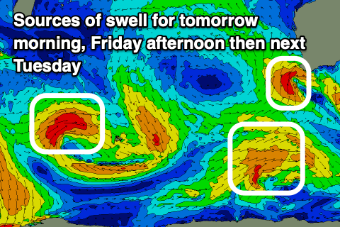
As touched on in Monday’s notes, there should also be a large SW groundswell in the mix tomorrow, generated by a strong polar low east of the Heard Island region earlier this week.
Both swells are due to ease into Friday as winds shift E/SE through the morning, creating cleaner conditions along with easing 4-6ft sets in the South West and 2ft sets to the north.
A reinforcing mid-period S/SW swell is due into the afternoon, easing Saturday, generated by a weak polar frontal system that’s currently south-west of the close-range low. It should maintain 4-6ft sets across the South West into the afternoon before easing into the weekend.
The weekend will be best again across the South West magnets with the easing swell under E-E/NE offshores Saturday morning ahead of sea breezes. The South West only looks to be 3-5ft or so Saturday with Sunday coming in smaller under an E/SE offshore.
Longer term the outlook is slow into next week with only a couple of long-range W/SW swells due Tuesday through Thursday.
The sources are relatively weak storms firing up south-west of South Africa, with Tuesday’s swell coming in smallest, better later Wednesday/Thursday. Local conditions look clean each morning ahead of sea breezes.