Fun weekend and Monday

Western Australian forecast by Craig Brokensha (issued Friday April 18th)
Best Days: The South West tomorrow morning and Sunday, the South West Monday ahead of sea breezes
Features of the Forecast (tl;dr)
- Easing surf Sat with moderate E/SE winds ahead of relatively weak S sea breezes
- Small reinforcing SW swell Sun with fresh E/NE tending variable winds
- Large, inconsistent SW groundswell building Mon, peaking later, easing Tue
- Fresh E/NE winds, tending variable S/SE Mon, strong NE tending N/NE winds Tue
- Strong N/NW tending W winds Wed with a building localised stormy swell
Recap
There was a window of clean conditions early yesterday in the South West with plenty of large swell still in the mix before a strong onshore change hit shortly after, with peaky and improving waves to the north still to 2-3ft across Mandurah and 2ft in Perth.
Today was smaller but wind affected with protected spots offering the best waves.
This weekend and next week (Apr 19 - 25)
The weekend looks fun across the South West with a further drop in energy from today, coming in around the 4ft range tomorrow with a small reinforcing swell Sunday maintaining similar sized waves.
Perth and Mandurah look tiny and a moderate E/SE winds will create clean conditions tomorrow morning before shifting more S’ly into the afternoon, with fresh E/NE tending variable winds on Sunday.
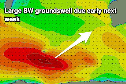
Now looking at Monday’s SW groundswell and there’s been no changes to the expected size, though the timing of the peak might be shifted back to the evening, with similar sized waves due into early Tuesday.
The source of this swell was a strong but distant frontal progression that started south of South Africa and travelled east towards the Heard Island region the last couple of days. Multiple fetches of severe-galeforce winds should produce an inconsistent SW groundswell that’s due to reach the 8ft+ range into later Monday across the South West, 2-3ft Mandurah and 2ft+ Perth before easing from a similar if not slightly smaller size Tuesday.
Local winds look great as the swell builds with a fresh E/NE’ly, shifting S/SE into the mid-late afternoon, with Tuesday seeing early strong NE winds, tending more N/NE through the day.
This will be ahead of a trough and possible strong N/NW tending W’ly winds Wednesday if it forms into a surface low. The models diverge on this and the possible large swell from a polar frontal progression leading up to it. GFS has it bigger and cleaner but EC puts the energy into the mid-latitude low so we’ll have to review things on Monday when the models come into alignment. Have a great weekend!