Decent swell mid-week, cleanest as it builds

Western Australian forecast by Craig Brokensha (issued Monday April 14th)
Best Days: Wednesday ahead of sea breezes, protected spots Thursday, Saturday morning in the South West
Features of the Forecast (tl;dr)
- Smaller tomorrow with light-mod S/SE-SE tending S/SW winds
- Large SW groundswell building Wed, peaking late/into the evening with E winds ahead of relatively weak sea breezes, strongest later
- Slowly easing large SW groundswell Thu with strengthening S/SE winds in the South West, S/SE tending S/SW to the north
- Smaller Fri with gusty S/SE winds in the South West, more E/SE-SE to the north
- Easing surf Sat with E/NE winds ahead of sea breezes
- Possible new swell Sun with E/NE winds, but EC doesn't litke it
Recap
Friday’s swell eased back temporarily into Saturday across all locations with less favourable winds and conditions, while into Sunday, our secondary pulse of long-range and inconsistent but large groundswell filled in.
The South West was a strong 8ft again with 2-3ft sets in Mandurah and smaller waves across Perth. Conditions were favourable nearly all day with this morning coming in much smaller with windier conditions across the South West.

Great surf yesterday morning
This week and weekend (Apr 15 - 20)
The best surf days are behind us this period, with smaller amounts of swell due tomorrow with deteriorating conditions as a trough moves in, bringing weak S/SE-SE tending S/SW breezes.
Wednesday morning actually looks offshore ahead of relatively weak sea breezes until later when they’ll really strengthen.
This will be along with a new, large SW groundswell on the build, generated by a strong polar low that formed around the Heard Island region last night.
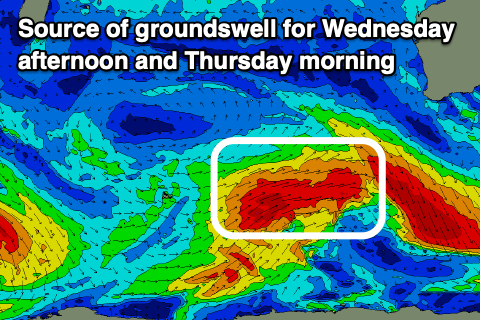
A great fetch of gale to severe-gale SW winds will be projected towards us today before weakening as the system pushes east, below us tomorrow, with a fun, quick spike in swell due to build rapidly through Wednesday, likely peaking into the evening and then easing Thursday.
The South West should build to the 8ft range later in the day Wednesday with 2ft to possibly 3ft sets seen in Mandurah and 2ft across Perth, easing from 6-8ft across the South West Thursday morning with 2ft+ waves in metro locations.
Local winds as stated look best Wednesday as the swell builds, with a trough due to bring less favourable, strengthening S/SE winds through Thursday as the swell eases.
Friday will become smaller and a fresh S/SE’ly looks to persist in the South West with better offshore winds to the north but with fading 1-1.5ft sets max.
The weekend will see offshore E/NE winds each morning across the South West but the swell will be small and fading with easing 3-4ft sets in the South West, tiny to the north Saturday, while the models diverge regarding a small pulse of S/SW swell Sunday.
Longer term the outlook becomes a bit more active into next week again, but with the model divergence we’ll have to review this Wednesday and Friday.