Best tomorrow morning, slow thereafter

Western Australia Surf Forecast by Craig Brokensha (issued Friday February 17th)
Best Days: Tomorrow morning in the South West and the keen Mandurah, Monday morning for the keen in the South West, next Friday morning
Features of the Forecast (tl;dr)
- Moderate sized SW swell building Fri, peaking in PM
- Easing surf Sat with E/SE tending strong S/SW-SW winds
- Smaller Sun with strengthening S/SE-SE winds
- Small mid-period SW swell for later Sun, easing Mon with fresh SE winds ahead of sea breezes
- Easing surf Tue with light E/SE-SE tending SW winds
- New, mid-period SW swell building Thu PM, peaking Fri with S/SE tending S/SW winds
- Easing surf Sat with E/SE tending S/SW winds
Recap
Great conditions in the South West with a drop in swell back to 4-5ft yesterday morning, 1-2ft in Mandurah and 1.5ft+ across Perth.
This morning the swell is similar in size but with onshore winds lingering after yesterday's change, cleaner to the north.

Good surf yesterday AM

Lines of swell with the onshore yesterday PM
This week and weekend (Feb 18 - 24)
We should see a touch more size in the swell this afternoon, linked to the front bringing the current average winds. Sets to 5-6ft should be seen in the South West, holding 1-2ft in Mandurah and 1-1.5ft across Perth before easing tomorrow from 4-5ft+ and 1-1.5ft respectively.
Winds are looking great with an E/SE offshore tomorrow morning, giving into S/SW-SW sea breezes, smaller Sunday with a S/SE-SE morning offshore.
Later Sunday and early Monday, a small glancing pulse of mid-period SW swell is due, generated by a 'bombing low' developing south-east of us tomorrow.
This low will only start to develop late in our swell window with a fetch of strong to sub-gale-force W/NW winds due to produce a small spike in swell to 3-5ft late Sunday easing from a similar size Monday morning. Perth and Mandurah will be tiny.
Winds will be OK but not great and fresh out of the SE on Monday morning, lighter Tuesday morning and E/SE-SE but with a small, fading swell.
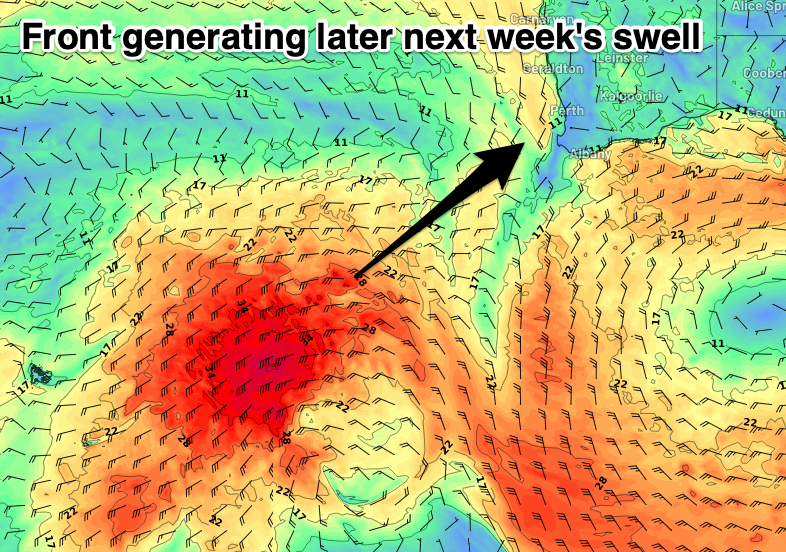
There's nothing significant on the cards until later in the week and winds will turn to the S'th and freshen into the middle of the week, blowing stronger SW into Thursday.
This will be linked to the backside of a healthy but weak fetch of strong W/SW winds projecting up and towards us into the end of the week, bringing the increase in swell for later in the day but more so Friday.
It only looks moderate + in size but to sets to 6ft+ are due in the South West Friday, 2ft in Mandurah and 1-2ft across Perth but with S/SE tending S/SW winds.
Saturday should be cleaner with the swell on the ease under an E/SE offshore. Following this there's nothing too major on the cards so check back here on Monday for the latest update. Have a great weekend!