Improving surf through the week

Western Australia Surf Forecast by Craig Brokensha (issued Monday January 30th)
Best Days: Selected spots tomorrow morning in the South West, Wednesday morning, Thursday morning in the South West, Friday morning in the South West, Saturday and Sunday in the South West ahead of sea breezes
Features of the Forecast (tl;dr)
- Reinforcing moderate sized SW swell building tomorrow with fresh S/SE-SE winds in the South West (strong S/SE PM), with S/SW sea breezes to the north
- Moderate sized + SW swell Wed with strong but easing SE tending S/SE and strengthening again into the PM (E/SE tending S/SW sea breezes to the north)
- Easing swell Thu with strong E/SE tending S/SW winds
- Fun S/SW groundswell Fri AM with strong but easing E/SE winds ahead of mid-PM sea breezes
- Moderate sized S/SW groundswell filling in Sat, peaking in the PM, easing Sun
- Moderate to fresh E/NE tending weaker NE winds ahead of mid-PM sea breezes
Recap
Some nice clean waves to 3ft in the South West owing to a building mid-period swell, peaking into the afternoon and then easing back from 3ft yesterday with less favourable winds. To the north conditions were clean but tiny.
Our large mix of SW groundswell and mid-period energy due into today looks to have gone AWOL. No major size is showing on the buoys or cameras with windy surf to 4-5ft in the South West, tiny to the north.
The low linked to this swell did race ahead of itself, but regardless we should be seeing consistent 6ft sets but alas it's smaller and slower.

Bumpy sets but not overly sizey this AM
This week and weekend (Jan 31 – Feb 5)
While today's mix of expected sizey swells have gone missing we do have a good week of waves ahead with improving winds and some fun, reinforcing SW swell energy.
Today's mix of swells will ease through tomorrow, but from what size? Some fun reinforcing energy is due to fill in tomorrow, regardless, generated by pre-frontal W/NW gales ahead of a great fetch of strong to gale-force W/SW winds attached to a broad polar frontal progression.
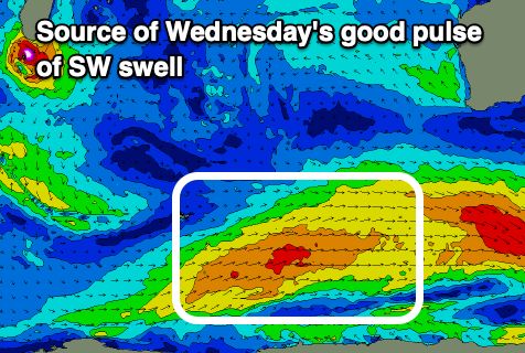
Sets to 4-5ft are due, with a possible further increase in size due into the afternoon, with the mid-period energy coming in at 6ft+ across the South West Wednesday, 2ft in Mandurah and 1-2ft in Perth.
Looking at the local winds and we've still got gusty S/SE-SE breezes due tomorrow morning ahead of stronger S/SW sea breezes to the north, holding from the S/SE in the South West but also strengthening.
Wednesday looks the pick as winds shift SE, remaining strong but easing into the late morning before going S/SE and strengthening again. Better E/SE winds should be see in Perth and Mandurah through the morning.
A better E/SE offshore is due on Thursday with easing surf from 4-5ft+ in the South West, 1-2ft Mandurah and 1-1.5ft in Perth.
Into Friday a new pulse of S/SW groundswell should be seen across the South West in the morning, generated by a strengthening polar low on the back of the progression generating Wednesday's swell.
It looks to strengthen a little too late than ideal for us but fun 4-5ft sets should continue on the south magnets in the South West along with strong but easing E/SE winds ahead of sea mid-afternoon sea breezes.
Winds will start shifting E/NE into the weekend ahead of another pulse of S/SW groundswell which will favour the South West but not locations further north.

A deepening extra-tropical low will drop south-east through our swell window, producing a fetch of severe-gale W/NW winds through our southern swell window on Wednesday evening.
While again not ideally aimed, the wind strength should somewhat over power this with a good kick in size through Saturday to 4-6ft due in the South West as winds tend variable ahead of weak sea breezes.
Sunday will see E/NE-NE winds again ahead of sea breezes as the swell eases and then a S/SE change as a trough slips south-east Monday.
Longer term the outlook is a bit mixed with less than ideal winds most of next week and smaller, weaker swells but we'll confirm this Wednesday.
Comments
Hi Craig. I was wondering if at some point you might be able to provide a little background into the anomaly of the AWOL swell today? An overview of what may have happened, whether related to local bathymetry, the swell direction, the low racing ahead of itself, etc. Might be interesting fodder for another informative article? The articles covering oceanography, bathymetry, meteorology, etc on this site are always epic for those of us with a nerdy side.