Coupla large swells on the way

Western Australian Surf Forecast by Ben Matson (issued Wednesday 5th May)
Features of the Forecast (tl;dr)
- Improved outlook for Thurs with solid swells in Margs and generally light winds
- Another large swell for Sat with generally light winds
- Even larger swell due next Wed/Thurs
Recap
Wave heights eased a fraction more quickly into Tuesday than expected, with 4ft surf in Margaret River early morning down to 2-3ft by the afternoon, clean on top with fresh offshore winds at times. Perth and Mandurah were tiny and clean. This morning saw the bottom of the swell cycle with only small waves on offer across all regions. Early light N/NE winds in Margaret River swung moderate W’ly around lunchtime with afternoon wind speeds generally in the 10-15kt range. Winds were a little lighter across metro coasts. The leading edge of a new long period groundswell reached the coast this afternoon, with the Cape Naturaliste buoy showing Tp of 18 seconds around 7pm. Wave heights are trending upwards though the bulk energy is still yet to show properly.
This week (May 6 - 7)
The wind outlook for Thursday has improved since Monday’s notes, thanks to a cut-off low now being positioned a little further west than initially expected. We’ll see winds gradually freshen from SW into the afternoon but it should remain light enough prior to then to allow for reasonably good conditions across most regions.
That being said, some of the high res models are showing a trough/mesoscale low west of Bunbury in the morning that may bring a freshening W/NW breeze to Perth and Mandurah mid-late morning and then a brief period of gusty SW winds early/mid afternoon. The specifics are low confidence though. Margaret River probably won't see much strength in the breeze until dinnertime.
As for surf, we should see a broad plateau in size across the Margaret River region, with light variable winds and inconsistent sets around the 8ft mark. Metro beaches will be smaller with 2ft+ sets in Mandurah and 1-2ft waves across the Perth region.
Friday now looks like it’ll be post-frontal with moderate S/SW breezes across the Margs region, that’ll probably become an early SE flow across Perth and Mandurah before trending moderate southerly through the day.
Surf size will ease to an inconsistent 4-6ft in the lower SW, with only 1-2ft waves across the metro beaches.
This weekend (May 8 - 9)
Our new swell for Saturday is still looking very solid. And, a relaxing pressure gradient should allow for a period of slack winds early morning. Note: this isn’t offshore, which would otherwise iron out any bumps from Friday’s cross-onshore breeze, however it should certainly be an improvement in quality.
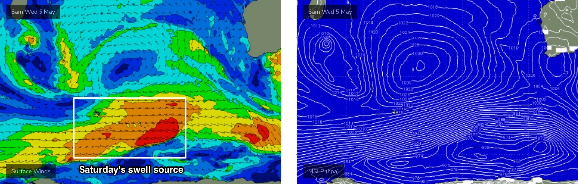
We haven’t been able to get a good satellite pass of the low south of Madagascar, so there’s no visual confirmation of core wind strengths but the model guidance has slightly downgraded this system (see below) so I’m going to pull back estimated wave heights a touch, to 8-10ft+ across exposed parts of the Margs coast, reaching 2-3ft in Perth and 3-4ft in Mandurah.
A weak front will clip the region into the afternoon and freshen W/SW winds across the lower SW (but not affecting metro coasts). This breeze - whilst not overly strong - is expected to linger into Sunday morning before easing through the day, so surface conditions may be a little compromised at exposed spots.
Surf size will also ease slowly, still around 8ft early morning but down to 6-8ft throughout the day.
Expect a similar easing trend across Perth and Mandurah coasts (2ft+ and 3ft+ early respectively, smaller later) with early light variable winds and afternoon sea breezes.
Next week (May 10 onwards)
Long term models are still pointing towards another large swell event later Wednesday/Thursday next week, that could push back into the 10-12ft range. However it will probably be accompanied with fresh southerly quadrant winds as the associated front clips the coast at around the same time.
More on this in Friday’s update.
Comments
Forecast will be a little late this evening, apologies.