More wind, and some OK swell

Western Australian Surf Forecast by Craig Brokensha (issued Friday 5th February)
Best Days: Saturday Margs and Mandurah, selected spots Sunday out of the wind, Thursday morning protected spots in Mandurah and Margs
Features of the Forecast (tl;dr)
- New, inconsistent SW groundswell building Sat PM with fresh to strong E/SE tending stronger SE winds, easing Sun with strong SE winds
- Limited swell potential from tropical low and onshore Mon
- Building mid-period S/SW swell Wed with onshore winds, easing Thu with S/SE winds
Recap
A little slow to start yesterday with the new mix of S/SW swells not arriving until mid-late morning in Margaret River, with winds limiting the best waves to protected spots.
This morning there was still plenty of size about in the South West with cleaner conditions, but winds have quickly strengthened and shifted more south again. Mandurah is offering a small 1-2ft wave, while it’s tiny in Perth.
This weekend and next week (Feb 6 - 12)
The surf will continue to ease into tomorrow morning, with the South West magnets the pick under strong SE tending E/SE winds through the morning, shifting more SE-S/SE into the afternoon.
During the day we’ll see our new SW groundswell fill in, generated this week by a strong polar low pushing along the polar shelf. This swell looks similar to yesterday’s with it coming in a little less consistent if anything owing to it being generated a touch further away and by a smaller system.
The South West should see 5-6ft+ sets, 2ft in Mandurah and tiny across Perth. It’ll ease back through Sunday and strong SE winds (possibly E/SE at times in the South West) will limit options, so hit up protected spots.
Now looking at tropical low that’s soaking the state and slowly moving south, this doesn’t look favourable for quality swell generation at all.
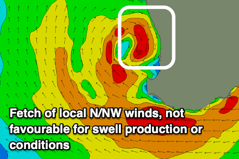 It is due to move offshore Sunday, bringing a fetch of strong to gale-force N’ly winds down the coast Monday, but the localised windswell generated by the low will also come with strong N/NW winds, shifting W/NW-W/SW in its wake, leaving no opportunity for a clean wave.
Tuesday looks to remain onshore out of the W/SW-SW with no notable swell.
The rest of the week is fairly hit and miss with a weak cold front projecting towards us early-week due to form into a mid-latitude low directly south-west of us Tuesday. This will produce a moderate-large, mid-period S/SW swell for later Wednesday/Thursday morning but with strong onshore winds on the former, fresh S/SE Thursday.
Protected spots won’t be great with the swell direction and low period nature, with easing sets from 4-5ft likely across the South West, maybe 1-2ft in Mandurah and tiny across Perth.
Longer term, a large blocking high will keep things quiet, so try and make the most of the coming, windy swell. Have a great weekend!