Windy outlook but with two similar swells

Western Australian Surf Forecast by Craig Brokensha (issued Wednesday 3rd February)
Best Days: Thursday, Friday morning in the South West, Saturday, selected spots Sunday out of the wind
Features of the Forecast (tl;dr)
- Mix of S/SW groundswell and mid-period swell for tomorrow with strong SE winds, easing Fri with a touch less wind
- New, inconsistent SW groundswell building Sat PM with fresh to strong E/SE winds, easing Sun with strong SE winds
- Limited swell potential from tropical low
Recap
Clean, easing and fun waves across Margs and Mandurah yesterday morning following Monday's swell, giving into a late onshore change, smaller today and wind affected as we fall in between swells.
This week and weekend (Feb 4 - 7)
The low point in size today won’t last long with a good mix of new long-period S/SW groundswell and mid-period swell due to fill in tomorrow across the South West, with less impact further north.
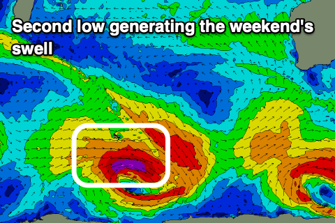
 The source of both swells was a strong polar low forming south-west of us earlier this week, directing a great fetch of severe-gale to storm-force W/SW winds on the edge of our southern swell window, while a front projecting up on the back of the low, towards the Bight, has generated the mid-period energy.
Both swells are expected to peak tomorrow with sets to 6ft+ across the South West, 2ft in Mandurah and tiny in Perth owing to the southerly origins.
Winds will remain strong tomorrow and out of the SE through the morning for the most part, S/SE into the afternoon. Friday looks similar in the South West but with a bit less wind, with winds shifting more E/SE around Perth and Mandurah. The swell will be on the ease and backing off from 4-5ft+ in the South West, 1-1.5ft across Mandurah and Perth.
Looking at the weekend and winds should improve, swinging more E/SE across the South West but with a low point in swell through the morning. A new, inconsistent SW groundswell is due into the afternoon though, generated by another strong polar low, not too dissimilar to the one generating tomorrow’s. This one will be a little smaller in scope but form a touch further west.
 Size wise, the South West should build to 5-6ft+ Saturday afternoon, with it coming in around 2ft across Mandurah, tiny in Perth. Winds should remain favourable all day into the afternoon as well.
Sunday looks less favourable as the swell eases under strong SE tending S/SE winds.
Now, coming back to the tropical low to our north and it failed to reach cyclone strength, with it now due to linger inland over the coming days. We may see it push offshore and strengthen on the weekend, bringing some localised N/NW windswell, though EC isn’t on board, with nothing of note at all as the low stays inland while tracking south. We’ll continue to watch this and provide another update Friday.
Comments
The monsoon froth trough hasn't produced any cyclones in WA. No deep meaningful waves just magical life giving rain, an explosion plant growth and insects. Delightful except for the F_ing flies!
RC, bit cooler for you as well. Its magical when the rain comes at this time of year, life sprouting in front of your eyes. Damm the bloody flies.