Make the most of the current swell

Western Australia Surf Forecast by Craig Brokensha (issued Monday 21st October)
Best Days: Tomorrow morning, next week
Features of the Forecast (tl;dr)
- Easing surf ahead of a weak S/SW swell late week
- Better, though very inconsistent W/SW groundswell for mid-late next week
Recap
A clean morning Saturday but with no decent swell, bumpy yesterday with cross-shore winds.
Today our new mix of swells have filled in with building surf across the South West and clean conditions. We’re now seeing sets hit the 6ft range but the sea breeze won’t be far off. Perth and Mandurah were tiny but we’ve now got 2ft sets.

This week and weekend (Oct 22 - 26)
Try and make the most of today’s inconsistent SW groundswell and mid-period S/SW swell as we’ll see it ease tomorrow, followed by another slow outlook.
The Southern Annular Mode, an index linked to how far north or south of normal the westerly storm track sits is strong positive, keeping the storm track retracted to the south and subdued.
This also sees high pressure move in across our main swell windows, putting a block on any major activity, hence the run of small swells.
We should see today’s swell easing back tomorrow with SE tending E/SE winds (ahead of sea breezes), creating clean conditions but it’ll mostly be best for the Margs region with easing 4-5ft sets, 1ft to possibly 2ft further north.
Wednesday will be clean but the swell bottoming out and with an E/SE tending E offshore ahead of sea breezes.
Into the end of the week a slight increase in small, mid-period S/SW swell is expected, generated by a weak polar front that’s currently east of the Heard Island region. The fetch strength didn’t get close to gale-force, with the size only likely to reach 3-4ft on the swell magnets later Thursday, easing from a similar size Friday. Perth and Mandurah will remain tiny. There’s also expected to be some infrequent long-period swell in the mix but with no size.
Winds will be offshore Thursday morning, but as the swell builds sea breezes will be in, while Friday looks dicey with stronger S/SE breezes.
The weekend doesn’t hold much hope for better surf with easing swells and persistent morning S/SE winds with strength.
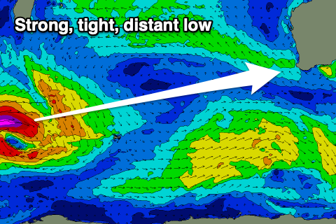 The next note-worthy swell is due to arrive mid-next week with it being generated by a distant, strong, though tight low forming south of South Africa on Wednesday evening.
A great fetch of severe-gale to storm-force W/SW winds will be aimed towards us, but quite a distance away, with the low tracking east-southeast while weakening. A very inconsistent, long-period W/SW groundswell is due from this source, arriving later Tuesday but more so Wednesday, building through the day ahead of a peak overnight/Thursday morning.
Very inconsistent 5-6ft sets are due on the South West magnets, 1-2ft in Perth and Mandurah but with what looks to be morning offshore winds. We’ll continue to watch this swell over the coming week though.