Good swell early next week

Western Australia Surf Forecast by Craig Brokensha (issued Friday 18th October)
Best Days: Saturday morning for the keen in the South West, Monday morning, Tuesday morning in the South West, similar Wednesday morning for the keen
Features of the Forecast (tl;dr)
- Small kick in swell tomorrow with clean conditions, less favourable Sunday
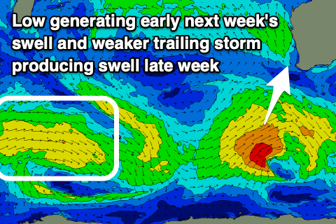
- Better mix of swells Monday with offshore winds, building again late week
Recap
Clean conditions each morning but small to tiny, fading surf across all regions.
This weekend and week (Oct 19 - 24)
We should see a small lift in swell across mainly the South West tomorrow as a small, mid-period S/SW swell fills in. This has been discussed throughout the week and Margs should offer 3-4ft sets, tiny to the north and likely 1ft to maybe 1.5ft.
A morning SE breeze should create favourable conditions before strong sea breezes kick in.
This swell is due to ease Sunday ahead of our inconsistent, building long-period SW groundswell. The source of this long-period energy was a strong, though tight and distant low firing up west of Heard Island and sets should build to 4ft through the afternoon across the South West.
Less favourable and fresh to strong morning S/SE winds will swing stronger S/SW into the afternoon, creating average to poor conditions as the new swell kicks.
Our secondary, lower period pulse of S/SW swell for Monday is on track with a secondary low forming around the Heard Island region last night. This low is producing a fetch of pre-frontal W/NW gales, followed by weaker strong to gale-force W/SW winds as it projects east-northeast over the coming days.
 The swell should peak Monday and offer consistent 6ft sets, with the odd sneaky bigger one, 2ft in Mandurah and 1-2ft across Perth. Conditions are looking great with fresh morning E/SE offshores ahead of S/SW sea breezes.
Tuesday looks clean again but the swell will be on the way out, small Wednesday.
Into the end of the week, a new mid-period SW swell is due from a weaker polar front developing in the wake of the low generating Monday’s swell. Fetch strength won’t be overly strong but we should see 3-5ft sets as the swell fills in Thursday afternoon, easing Friday.
Winds look favourable Thursday morning and offshore ahead of a trough and S/SE winds Friday. We’ll have a closer look at this Monday though, have a great weekend!