Average until large back to back swells arrive from Wednesday

Western Australia Surf Forecast by Craig Brokensha (issued Monday 13th April )
Best Days: Every morning from Wednesday
Recap
Nothing to really surf over the weekend with onshore winds and small amounts of swell. Today conditions have improved slightly with better winds and a bumpy 3ft of swell in the South West and clean 1-1.5ft waves up around Perth.
This week (Apr 13 - 17)
Tomorrow will become more active than today with a slight lift in long-range W/SW groundswell across the South West and Perth, building from 3-4ft to 3-5ft into the afternoon with Perth hanging around 1-1.5ft. Conditions look average though and a light to moderate onshore W'ly breeze in the South West due to give way to a fresh to strong S'ly change through the day. Perth may be clean early before the onshores kick in.
Of much greater importance is back to back large pulses of groundswell due from Wednesday through Saturday across the state.
This will be linked to a strong node of the Long Wave Trough moving through the southern Indian Ocean over the weekend and then across us early this week.
With this a series of vigorous polar lows are firing up in our swell window, the first developing south-east of South Africa Saturday and pushing towards us over the weekend while generating a fetch of severe-gale to storm-force W/SW winds.
The swell from this system should arrive Wednesday morning and build to a large 8-10ft+ across the South West into the afternoon and 2-3ft in Perth later in the day. Gero should pulse to 3-5ft late and peak Thursday morning to 4-6ft.
Across Margs and Perth the swell should back off a touch into Thursday morning to the 8ft and 2-3ft range respectively but a new pulse of long-period SW groundswell is due into the afternoon, generated by a secondary polar low forming south-west of the state tomorrow.
A pre-frontal fetch of severe-gale W/NW winds will be generated followed by a better aligned fetch of W/SW winds. Two close-spaced SW groundswell pulses will be produced, building back to 10ft Thursday afternoon in the South West and maintaining 2-3ft in Perth.
Gero should see this swell for Friday morning, coming in at 4-6ft again. Margs and Perth should see similar sized waves to Thursday afternoon before easing into the afternoon.
Winds are looking great Wednesday and Thursday with morning offshore E/SE breezes on the former and straighter E'ly winds Thursday morning while Friday morning will see variable (tending offshore winds) ahead of a shallow SW change in the South West.
 This weekend onwards (Apr 18 onwards)
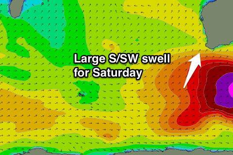
The largest of all the groundswell pulses is due for Saturday as the broadest and strongest of the polar lows fires up to our south-west Thursday, aiming a fetch of storm-force SW winds through our southern swell window.
A large and powerful long-period S/SW groundswell is expected to be generated, arriving early Saturday peaking through the middle of the day to 10-12ft in the South West with the odd bigger bomb at offshore reefs, 3ft+ in Perth into the afternoon and building late to 4-5ft in Gero, peaking at 5-6ft+ early Sunday.
Winds are looking excellent and offshore from the E and then from the NE Sunday as the swell eases, but we'll confirm this on Wednesday.
Comments
Some epic sessions ahead
Craig do you know why the swell bouys haven't been working?
Nah I don't sorry, super annoying!