Tricky outlook with limited windows for a clean wave

Victorian Surf Forecast by Craig Brokensha (issued Monday January 8th)
Best Days: Tomorrow morning to the east for the keen, Friday morning
Features of the Forecast (tl;dr)
- Small surf tomorrow, easing Wed
- Moderate E/SE-E tending fresh S/SE winds tomorrow
- Variable winds early Wed, shifting S/SW mid-AM and strengthening
- Light-moderate S/SE winds Thu AM, variable to the west
- Small-mod sized, mid-period W/SW swell building Thu, peaking Fri AM with variable NE tending S winds
- Strengthening S winds Sat, strong E/SE-SE on Sun
Recap
Fun waves across the exposed beaches on the weekend with semi-clean 3ft+ surf Saturday to the east, a touch smaller yesterday and back to 2-3ft. The Surf Coast offered OK 2ft peaks on the beaches Saturday, down to 1-2ft yesterday.
Unfortunately today a trough has moved in earlier than forecast last Friday, bringing poor onshore winds and average surf.

Wonky sets Saturday AM
This week and weekend (9 - 14)
The coming forecast period will consistent of generally small to moderate sized surf with tricky, varying winds thanks to persistent troughy weather.
Some new, background SW swell that's in the water today is due to ease tomorrow and winds will quickly improve, shifting E-E/SE through the morning. Selected spots to the east will be OK for the keen with easing 3ft sets+, 2ft and onshore to the west.
Wednesday looks dicey as the swell continues to ease, with a trough expected to move through mid-morning. There should be a period of variable winds ahead of it, but lower your expectations with easing 2ft sets on the Surf Coast magnets, 3ft+ to the east.
The change will bring freshening S/SW winds during the morning, stronger into the afternoon, easing back on Thursday but likely still onshore from the S/SE to the east, possibly variable to the west.
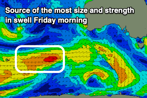
Swell wise, some new mid-period W/SW swell should be on the build through Thursday, peaking Friday morning. The source is a relatively weak but persistent frontal progression moving in from the south-west of Western Australia.
Strong W/SW winds are due for the most part with a small burst of stronger gales through this evening, generating the peak Friday morning.
It'll be weak and peaking to 2-3ft on the Surf Coast magnets Friday morning, 4ft to occasionally 5ft to the east with what looks to be variable NE morning winds, fresh S/SE into the afternoon.
On the Surf Coast we may see variable SE winds but we'll have a closer look at this on Wednesday.
Make the most of Friday morning's window of waves, as Friday afternoon's change will be linked to a trough moving through followed by a strengthening high, bringing strengthening S'ly winds Saturday, stronger E/SE-SE into Sunday.
This will kick up some localised SE windswell with no major background SW energy as the Southern Ocean goes a little quiet.
Early next week we'll likely see winds go E/NE-E with easing levels of SE windswell but we'll take a closer look at this on Wednesday.
Comments
Putrid.
It was fun on Sunday, wind had N to NE in it at times I think and certain places were out of it, a really nice day of waves working around the tide. There was the odd wave nearly head high where we were, but mostly lulls and a lot of 2ft.
Nice.
Some fun ones over this side too but the traffic was insane.
The combination of a major music event, the fact the rock is now a suburb of Melbourne and every person and their furry friends decided it was the first beach day of summer to come down and set up their Hacienda.
Made for chaos.
Have my pushie set up with board racks for such occasions but you cant even ride it over the bridge as the planners in the past made the pedestrian access way too narrow and the foot traffic was almost as bad as the vehicle traffic.
Had to go East. Never seen so many people on the Bass Coast SW facing beaches.
That song where have all the flowers gone.....where have all the NEasters gone is more like it.
Any chance of 3-4 offshore days in a row this summer craigos?
I’ve started looking at the NSW forecasts
Ok I’m new to Vic from mid NSW. I have a new board that’s been in a board bag for two months due to onshore shit winds. I’m guessing that’s not usually the go here and it looks onshore for quite some time to come. Any idea for the outlook to come? Don’t roast me I know I have to put time in to suss it out. Just curious. Cheers.
Should’ve been here in winter mate
It was offshore for weeks !!!
Yep!
Weekend was great fun both days Eastern Victoria. Summer in the East, Winter in the West.