Tricky outlook due to local winds

Victorian Surf Forecast by Craig Brokensha (issued Monday 27th February)
Best Days: Tuesday morning Surf Coast, Thursday morning Surf Coast, selected spots later Saturday morning, Sunday morning for the keen Surf Coast, Tuesday morning
Features of the Forecast (tl;dr)
- Moderate sized, inconsistent SW groundswell building Mon, holding Tue, easing Wed
- Light, variable winds early on the Surf Coast tomorrow, light S'ly to the east, freshening from the S/SW through the day
- Easing swell Wed with gusty SW tending S/SW winds
- Smaller surf Thu AM with early W/NW tending gusty SW winds on the Surf Coast
- Moderate sized mid-period S/SW swell building Thu PM, peaking Fri with mod-fresh S/SE winds
- Easing surf Sat with E/NE-NE tending SE winds
- Smaller Sun with light W tending gusty SW
- Moderate sized mid-period S/SW swell building Mon, peaking Tue with possible variable morning winds
Recap
Clean conditions with a slow increase in inconsistent W/SW swell, 2-3ft during the morning to the east, a little bigger into the afternoon as a shallow trough brought weak onshore winds that freshened later.
The Surf Coast saw winds ease back off following showers, providing fun surf with sets to an inconsistent 2-3ft on the magnets
Yesterday morning was very slow and full but clean on the Surf Coast with the dropping tide revealing 2ft to occasionally 3ft sets for the patient. Winds were favourable until early afternoon ahead of strengthening SW winds.
Today we've got more size with a building SW groundswell but poor conditions thanks to a fresh S/SW breeze. We should see the Surf Coast reaching 4ft with 6ft sets to the east but with no let up in the wind.

New swell with piercing golden light Saturday evening
This week and weekend (Feb 28 – Mar 5)
Tomorrow morning is looking a little more favourable across the Surf Coast with winds due to be more variable across pockets, even light W'ly, while to the east light S'ly winds are due, with freshening S/SW breezes due across all locations during the day.
This afternoon's SW groundswell should hold through tomorrow, thanks to a reinforcing pulse arriving later morning, with sets expected to continue around 4ft on the Surf Coast magnets (expect mostly 3-4ft waves) and 6ft to the east.
Wednesday looks poor as the size starts to ease, with a fresh and gusty SW'ly due to shift more S/SW through the day, leaving no real quality options for a surf.
Thursday morning will be a little smaller again but likely not below 2-3ft on the Surf Coast magnets and early W/NW winds are expected before freshening from the SW through the day.
Into the afternoon and more so Friday, moderate levels of mid-period swell are due to fill in, but this is when winds will go poor again thanks to a ridge of high pressure muscling in from the west.
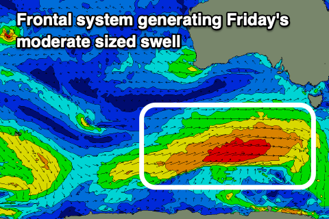
The swell will be generated by back to back polar fronts firing up under the country, the first today, to the south of Western Australia being relatively weak, ahead of a broader, stronger fetch of strong to gale-force W/SW winds tomorrow evening and Wednesday.
This secondary system will stall south of Tasmania on Thursday, with a secondary fetch of W/SW gales aimed through our southern swell window, drawing out the longevity of the swell into the weekend.
Looking at the expected size and Friday should see easy 4ft sets across the Surf Coast, 6ft to the east but with moderate to fresh S/SE winds, still solid Saturday morning but on the ease as winds tend E/NE-NE through the morning. The exposed beaches might still be a little too big and overpowered with 5-6ft sets, with better surf possible Sunday as the swell continues to ease as winds go light W'ly ahead of another trough and late morning SW change.
The Surf Coast will only be 2ft+ or so with a mix of easing S/SW swell and SE windswell.
Into next week another good pulse of S/SW swell is due along with tricky winds. A weak low moving in from the west may bring favourable winds both Monday and Tuesday mornings, with the later providing a peak in energy, but there's still plenty of divergence so check back here Wednesday for a clearer idea.
Comments
Sounding a little better now Craig, thanks. Get the stitches out Thursday so hopefully some waves over the weekend.