Get in now ahead of the change

Victorian Surf Forecast by Craig Brokensha (issued Monday 20th February)
Best Days: Today, beaches later morning Wednesday, Sunday morning Surf Coast
Features of the Forecast (tl;dr)
- Large SW groundswell building this afternoon with a shallow S/SW change late AM, freshening into the PM
- Steady drop in mid-period SW tending S/SW swell tomorrow with strong S/SE winds
- SE windswell and easing S/SW swell Wed with strong E/SE winds, tending E and easing a little, SE into the PM
- Fading small surf Thu with strengthening NE tending N/NE winds, easing into the PM
- Low point in swell Fri
- Inconsistent W/SW swell building Sat PM, peaking early Sun with fresh NW winds ahead of a strong PM SW change
Recap
Generally average surf on Saturday with a drop in swell from Friday with onshore winds across most spots, lighter and more offshore in pockets early across the Surf Coast.
Our new, fun sized mid-period W/SW and SW swell filled in through yesterday with great conditions on the Surf Coast in the morning with waves to 3ft, pushing to 4ft on the sets across the magnets through the day.
This morning the swell has eased off a touch but is still 3ft+ on the Surf Coast magnets with a variable wind and clean conditions, while the exposed beaches are a little lumpy and to 3-5ft.
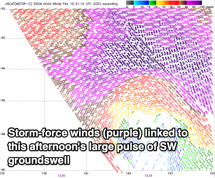
A trough will bring a shallow S/SW change late morning, with freshening winds due into the afternoon as a large pulse of SW groundswell fills in. This swell was generated by a 'bombing low' over the weekend, with it forming a touch later than forecast on Friday.
The swell has started to show with stronger sets hitting the magnets on the Surf Coast but the slightly later formation will likely restrict the peak in size this afternoon. We should still see the Surf Coast hitting 6ft+ with 8ft sets to the east but with those deteriorating conditions.

Building surf this AM
This week and weekend (Feb 21 - 26)
This afternoon/evening's peak in SW groundswell will be short-lived, thanks to the 'bombing low' linked to it tracking quickly to the east, under Tasmania last night.
We'll see a steady drop in size and power through tomorrow and conditions will be poor as a high pressure system moves in behind that's weak trough. Strong S/SE winds will limit options to a select few locations and we should see easing surf from 4-5ft on the Surf Coast and 6ft+ to the east.
Winds will swing to the E/SE-E and strengthen Wednesday as a trough deepens in the Bight, squeezing the northern flank of the high as it quickly transitions east.
The surf will be a mix of SE windswell and easing mid-period S/SW swell from 2-3ft on the Surf Coast and 3-4ft to the east. There should be a period of weaker E'ly winds later morning to the east and this will be the window to target on the beaches.
As the high transitions further east on Thursday, winds will shift more NE, strengthen from the N/NE later morning before easing a touch into the afternoon.
Size wise, we'll be looking at small to tiny, fading surf, easing from the SE and to 1-2ft on the Surf Coast, similar in size to the east.
The swell will then bottom out into Friday ahead of a new, inconsistent mid-period W/SW swell that will build through Saturday.

This has already started to be generated with a healthy polar low in the Heard Island region pushing east, generating sub-gale-force W/NW-W/SW winds. The low will continue to ease while projecting slowly towards Western Australia, with a fun sized, but inconsistent W/SW swell due to build Saturday afternoon, peaking early Sunday morning.
Gusty N/NE winds will shift S/SW late morning Saturday with a trough, clean Saturday morning on the Surf Coast with a fresh NW breeze ahead of a strong afternoon SW change.
Inconsistent 2-3ft sets are due on the Surf Coast magnets Sunday morning, 4-5ft to the east, easing Monday but with some localised SW swell in the mix but with strong S/SW winds.
Longer term there's nothing too major on the cards so make the most of today's waves.
Comments
Crazy to see 30knot Easterly blasting away on South Channel, and a 1-2knot Westerly not even ruffling the glass at the top end of the bay.