Fun beachy waves from mid-next week

Victorian Surf Forecast by Craig Brokensha (issued Friday 10th February)
Best Days: This morning, exposed beaches tomorrow morning for the keen, exposed beaches Wednesday and Thursday mornings, and next Friday
Features of the Forecast (tl;dr)
- Small, inconsistent leftovers tomorrow with variable E/NE-N/NE winds, tending strong SW mid-afternoon
- Building SW windswell Sun with strong W/SW tending SW winds (possibly W/NW dawn Surf Coast)
- Poor Mon with weak windswell and fresh to strong S winds
- Inconsistent, small mid-period W/SW swell building Tue, peaking Wed
- Mod-fresh S/SE winds Tue, light E/NE tending gusty SE Wed
- Stronger, but inconsistent W/SW groundswell building Thu, peaking in the PM with moderate NE tending gusty SE winds
- Easing swell Fri with strengthening N/NE-NE winds
- Building W/SW swells next weekend with winds out of the western quadrant
Recap
The easing trend of S/SW energy has been slow and winds have been favourable for both regions, initially average on the Surf Coast yesterday morning but improving through the day. Good sets to 3ft were still in the mix, clean fun 2ft leftovers this morning.
The exposed beaches to the east were still 3-4ft yesterday and hanging in at 3ft this morning with slightly bumpy conditions.

Good surf yesterday AM
This weekend and next week (Feb 11 - 17)
Looking at the size hanging in this morning, we should see inconsistent 2ft sets holding on the exposed beaches to the east tomorrow morning while the Surf Coast looks to bottom out, becoming tiny.
Winds will favour the beaches, tending light E/NE -N/NE through the morning and variable to the west before a trough brings a gusty SW change mid-afternoon.
Sunday will see a stronger W/SW-SW change moving through, possibly W/NW for a period at dawn on the Surf Coast but with no size.
Sunday's change will be linked to a weakening mid-latitude front pushing in from the west, with a low quality windswell due to build into the afternoon out of the SW, peaking Monday to 2ft on the Surf Coast and 3ft to occasionally 4ft to the east.
Conditions will remain poor though as a high moves in behind the weak frontal system, bringing fresh to strong S'ly winds Monday, moderate to fresh S/SE winds Tuesday.
Winds are still due to improve and shift E/NE on Wednesday morning along with an inconsistent, mid-period W/SW swell. This swell has been generated by a distant, weakening polar low the last couple of days, with the remnants being the mid-latitude front moving in Sunday.
It'll be very inconsistent but small 2ft sets are due on the Surf Coast Tuesday afternoon and Wednesday morning, with 3-4ft sets to the east.
A reinforcing pulse of stronger, inconsistent W/SW groundswell energy looks to maintain similar sized surf Thursday morning ahead of a peak in size through the afternoon.
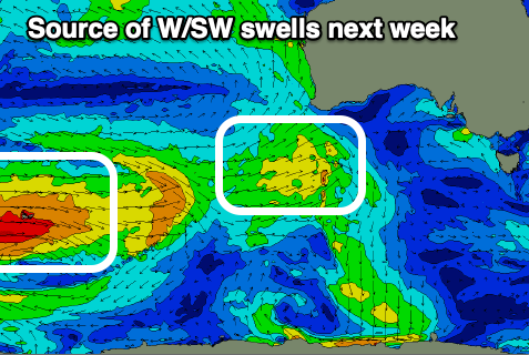
This is being generated by a strong polar low that fired up west of the Heard Island region yesterday, generating a great fetch of severe-gale W/SW winds.
The low will weaken over the coming days, with the swell due to build Thursday and reach 2ft to occasionally 3ft on the Surf Coast magnets, 4-5ft to the east. Morning NE winds will unfortunately give into SE sea breezes, but Friday looks good with strengthening NE winds as the swell slowly eases.
So all in all, the exposed beaches look fun from mid-week.
Longer term it looks like a series of healthy frontal systems will fire up to the south-west of Western Australia through later next week, generating some good W/SW swell energy with westerly winds from next weekend. More on this Monday, have a great weekend!
Comments
Check the Fairhaven Cam. Apparently a pink algae bloom due to cold meeting warmer waters. Maybe Craigos has a better explanation? Been a couple of big downpours down this way recently.
Further to above.
"The bloom is a dense concentration of marine plankton that causes a red-brown discolouration in the water and may be a species known as Noctiluca scintillans that can produce a glowing light at night as the water is disturbed, earning it the name Sea Sparkle," a DEECA Barwon South West spokesperson said.
https://www.bay939.com.au/news/local-news/138894-stunning-sea-sparkle-ap...