Winter calibre surf for the coming days

Victorian Surf Forecast by Craig Brokensha (issued Wednesday 1st February)
Best Days: Tomorrow, Friday protected spots, Saturday morning protected spots, early Sunday protected spots, Monday morning
Features of the Forecast (tl;dr)
- Moderate sized mid-period SW swell Wed PM and Thu
- Strengthening NW winds on Thu, tending W/NW late PM (lighter and N/NW at dawn)
- Large SW and W/SW groundswell building Fri with strong W/NW tending W/SW winds late PM
- Easing swell Sat with a moderate sized, reinforcing mid-period S/SW swell for the PM
- Strong W/NW tending SW winds mid-late AM Sat
- Easing S/SW swell Sun with fresh but easing SW tending S winds, likely W'ly early Surf Coast
- Moderate sized, inconsistent SW groundswell arriving later Sun, peaking Mon AM with variable tending S/SE winds
- Easing surf Tue with mod-fresh S winds
Recap
A moderate sized swell yesterday with 3-4ft waves on the Surf Coast and 5-6ft sets to the east with decent conditions across most regions. A weak S'ly created bumps to the lined up sets to the east and on the Surf Coast early W/SW winds created decent conditions before winds shifted to the S'th.
This morning is excellent condition wise with a great offshore wind on the Surf Coast and mix of mid-period swell and groundswell to 3-4ft, bumpy to the east and best across Phillip Island.
A trough has since brought a strong S/SW change, writing off the surf for the day.

The change is in
This week and weekend (Feb 2 - 5)
The swell from the strong polar low that projected towards us late last week and into the weekend is now being replaced by reinforcing mid-period energy. This has been generated by a broad polar frontal system that fired up behind the low, with prefrontal W/NW gales followed by strong to sub-gale-force W-W/SW winds.
The surf should hold 3-4ft across the Surf Coast tomorrow (with the possible rare bigger bomb at times on the magnets) and 5-6ft to the east as winds swing back to the N/NW at dawn, strengthening from the NW shortly after thanks to a strong polar low pushing up and into us.
The cold outbreak will bring a W/NW change into the late afternoon but what we're really interested in are the swell developments into Friday.
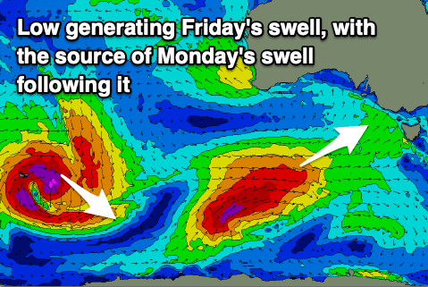
This low is currently south-southwest of Western Australia, with a fetch of gale to severe-gale W/SW-SW winds being generated in our south-western swell window, on top an active sea state.
The low will project north-east resulting in the fetch of gales moving more into our western swell window, aimed primarily into South Australia.
What this will result in is a mix of large SW and W/SW groundswell for Friday, solid in the morning but peaking into the afternoon.
The Surf Coast should build to 6ft+ with 8ft to occasionally 10ft sets on the Mornington Peninsula under a strong W/NW breeze that looks to only shift W'ly into the early/mid afternoon and then W/SW late afternoon.
The swell will ease into Saturday, but thanks to the stalling nature of the low, we'll see an additional fetch of strong S/SW winds projected up and into us Friday night and early Saturday, generating a sizey, reinforcing S/SW swell.
4-6ft surf should be seen all day on the Surf Coast with easing 6-8ft sets to the east and winds will be favourable for a short period in the morning, gusty W-W/NW ahead of a mid-late morning SW change.

Sunday will then see fresh, easing SW winds, likely early W'ly on the Surf Coast. Easing sets from 3-4ft are due on the Surf Coast, 4-6ft to the east.
A new long-period SW groundswell is due to arrive into later Sunday, peaking Monday. This is being generated by a strong extra-tropical low dipping south-east into polar latitudes while strengthening. It will produce a great fetch of severe-gale W/NW winds before weakening tomorrow evening, resulting in a moderate sized groundswell.
The Surf Coast should pulse back to 3-4ft+ on Monday morning with 5-6ft+ sets to the east with what looks to be variable E/SE-E winds in the morning. Freshening S'ly winds are likely on Tuesday as the swell eases with nothing too major swell wise to follow up into next week so make the most of the coming period!
Comments
Andddd winter is here... finally.
Winter in February.
Only a Victorian surfer knows the feeling.
Haven’t seen your face round here much.
Come for the notes. Stay for the complaining.
Hahahah
Careful bone, he can make people disappear
Gee it was nice this morning, loved seeing my preferred spot back in form, beautiful groomed lines rolling. The surf coast when like that is just so good to look at.
Yes, I would have to agree Dx3. Where I surfed was a bit small and inconsistent (the high tide didn't help) but was still a pleasure being out there getting a few in those conditions. I think just about every point and reef on the SC will light up at various times over next few days depending on the tide, wind, swell variations. Something for everyone and spreading the crowds a bit hopefully.
Agree re: high tide. Was pleasantly surprised at the crowd this morning. Good vibe in water, low-ish numbers. School back helps with holiday crowd mostly gone.
Craig, building to 6+ in the afternoon Friday. What size are you expecting in the morning?
Not too much smaller, I'd expect it to be 4-6ft by the peak of the tide.
Oh goody.
Out of interest Craig, we timed our run back from the west to coincide with the cooler air from that polar low last week, so I was watching Windy intently before leaving. As a result, temperatures during the driving day never got above 25, overnights were a cool 12-15, and we had a mint spot on the SA cliffs to watch the waves with an afternoon drink & nibbles in a cool onshore flow - it backed off to an offshore in the morning which looked pretty special. Layers of cloud are what the models don't tend to predict out on the Nullarbor - if you are under them it's quite pleasant.
Awesome and that is very cool for this time of the year, way under the averages!
https://www.willyweather.com.au/news/93517/summer+snow+to+bring+lowest+f...
"Temperatures are already dropping below average across southern states as the first of two fronts brings cool Southern Ocean air, but a more vigorous front with air directly from Antarctica will reach South Australia and Victoria on Thursday before sweeping through southern NSW overnight.
What will follow on Friday is a mid-summer day reminiscent of winter as maximum temperatures plunge as much as 15C below average.
It will be especially cold along the ranges, bringing snow down to an elevation of between 1,300 and 1,500 metres, equivalent to the snowline often seen during winter.
This event could bring the heaviest February snow since 20cm fell in 2005."
Porn!
Huge contrast between water temp and air temp. Be almost like surfing Sydney early winter/late autumn. Comfortable in boardies and the 2mm long arm vest.
Oh and great, uncrowded, solid, consistent surf!
Some places seemed to pump more than others today.
Winki has looked solid and crowded all day.
The place I surfed really seemed a bit patchy - at around 1pm I thought the swell had totally dropped out.
And then I checked the Winki cam a bit after and it was still pumping.
It's cold out there!