Small to moderate westerly swells, best Thursday

Victoria Forecast by Craig Brokensha (issued Monday 10th August)
Best Days: Later today Surf Coast, tomorrow morning Surf Coast (later in the day east of Melbourne), Wednesday east of Melbourne, Thursday through Sunday Surf Coast
Recap
Great fun waves Saturday across the Surf Coast to 2-3ft with bumpy larger surf on the Mornington Peninsula, that cleaned up later as winds tended NE.
Sunday was the day to surf east of Melbourne with offshores and a clean easing 3-4ft of swell, with small fun 1-2ft beachy waves on the Surf Coast.
Today the surf was tiny across the Surf Coast and only around 2ft on the Mornington Peninsula with a fresh to strong N'ly wind. A new long-range and inconsistent swell is due later this afternoon, to 2-3ft on the Surf Coast and 4-6ft on the Mornington Peninsula as winds swing NW.
This week (Aug 11 - 14)
This afternoon's increase in long-range SW groundswell should hold a similar size tomorrow morning but ease through the day, while a small cut-off low moving in from the South Australia will aim a fetch of W'ly gales through our western swell window this evening. This will generate an additional short-range W/SW swell for the afternoon to a similar size as the easing SW groundswell and winds will swing from the NW to N/NW, favouring selected locations across both coasts.
 Come Wednesday the swell will become small on the Surf Coast with 2ft sets max, and 3-5ft waves on the Mornington Peninsula under favourable N/NE tending variable and then SW winds.
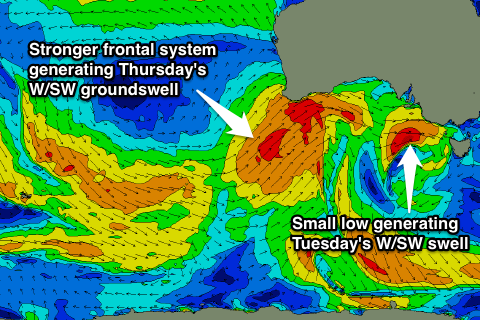
A fun pulse of inconsistent but strong W/SW groundswell is due Thursday, with it being generated by a broad and strong polar front pushing currently towards WA and then towards the Bight this evening. Unfortunately the system will move out of our swell window in the Bight as it forms into another cut-off low.
Still a good fun W/SW groundswell should be generated for Thursday to an inconsistent 3ft on the Surf Coast and 6ft on the Mornington Peninsula but with less than favourable W/SW tending W'ly winds (W/NW early on the Surf Coast). The approaching low may swing winds back to the W/NW late on the Surf Coast but we'll review this Wednesday.
A drop in size is due Friday, with a fun SW groundswell in the mix, easing from 2-3ft on the Surf Coast and 4-6ft on the Mornington Peninsula, best west of Melbourne with a NW tending W/SW breeze.
This weekend onwards (Aug 15 onwards)
The weekend's looking fun across the Surf Coast, with a moderate sized and good SW groundswell due to build through Saturday under offshore N/NW tending variable winds. The swell will be produced by a broad pre-frontal fetch of W/NW gales through the south-eastern Indian Ocean, followed by a trailing fetch of W/SW gales closer to us under the country later in the week.
The Surf Coast should build to an inconsistent but strong 3-4ft Saturday afternoon with 6ft to occasionally 8ft sets on the Mornington Peninsula, easing back from 3ft+ and 6ft+ respectively Sunday as winds persist from the NW.
Behind this a more consistent SW groundswell is likely early next week, but we'll review this Wednesday.