Fun Surf Coast tomorrow, east of Melbourne Sunday

Victoria Forecast by Craig Brokensha (issued Wednesday 5th August)
Best Days: Thursday morning Surf Coast, early Friday Surf Coast, Saturday Surf Coast (afternoon east of Melbourne), Sunday east of Melbourne, Monday afternoon onwards Surf Coast
Recap
Large, pumping and easing surf across the Surf Coast yesterday, dropping from the 6ft range under all day offshores. Today a mix of new short-range and stronger SW groundswell are building back across both coasts but early W'ly winds have since gone onshore, creating average conditions.
This week and weekend (Aug 6 - 9)
This afternoon's building mix of swells are due to now peak overnight/early tomorrow morning, but we'll still see large easing 4-6ft waves on the Surf Coast and 8ft sets on the Mornington Peninsula tomorrow morning, backing off from a smaller 3ft to possibly 4ft early Friday and 6ft+ respectively.
Winds will be best for the Surf Coast and only through the mornings with a W/NW'ly tomorrow morning tending W/SW at some stage through the afternoon (possibly holding from the W all day). Friday will see a small window with an early W'ly tending SW mid-late morning.
Come Saturday a small S/SW groundswell should keep exposed spots picking up inconsistent 2ft to sometimes 3ft sets on the Surf Coast and 4-5ft waves on the Mornington Peninsula, smaller than model forecasts, before easing back through Sunday. A long-range SW groundswell for Sunday doesn't look to offer any additional size, with easing surf from 2ft and 3-5ft respectively.
Winds will finally improve for the Mornington Peninsula though, mainly Sunday with a N'ly breeze due to persist all day. Saturday will be best west of Melbourne with a light NW tending variable wind.
 Next week onwards (Aug 10 onwards)
Monday will start tiny and with fresh to strong NW winds as a flurry of strong frontal activity approaches from the west.
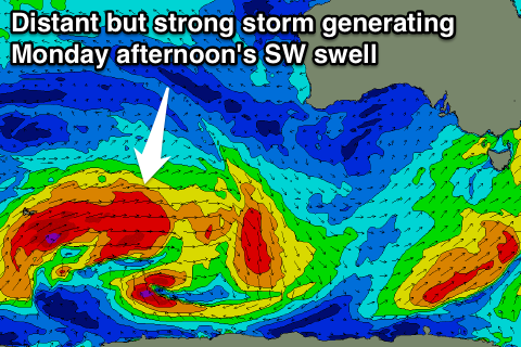
A very inconsistent long-range SW groundswell is due to build through the day, mixed in with a building short-range W/SW swell.
With the NW winds the Surf Coast will be the only option and only a small kick in size to a very inconsistent 2-3ft through the day (5-6ft on the Mornington Peninsula).
Come Tuesday the swell should hold in the 2-3ft range as NW winds persist, but we've got some better and larger W/SW groundswell due into Wednesday and beyond.
This will be related to a series of stronger frontal systems moving through our western swell window early next week, but we'll have a closer look at this on Friday.