Easing surf, with fun beachy waves from Tuesday

Victoria Forecast by Craig Brokensha (issued Friday 10th April)
Best Days: Saturday morning both coasts, Monday morning both coasts, Tuesday and Wednesday east of Melbourne
Recap
Good and easing levels of SW groundswell from 3-4ft+ across the Surf Coast yesterday and 6ft on the Mornington Peninsula with bumpy conditions under light to moderate onshore winds.
Today the swell was smaller and more around 3ft on the Surf Coast and 4-6ft on the Mornington Peninsula as onshore winds persisted from the S/SE.
This weekend (Apr 11 - 12)
A reinforcing SW groundswell for today should ease through tomorrow and further into tomorrow as conditions finally improve with a light variable breeze that may tend locally offshore in regions across the state. The Surf Coast should ease from 2-3ft with the Mornington Peninsula dropping from 4-5ft.
Come Sunday morning smaller waves are due but with a freshening S/SE'ly. A new inconsistent SW groundswell is due into the afternoon to 2-3ft and 3-5ft respectively but with no quality options. So Saturday morning is the time to surf over the weekend.
Next week onwards (Apr 13 onwards)
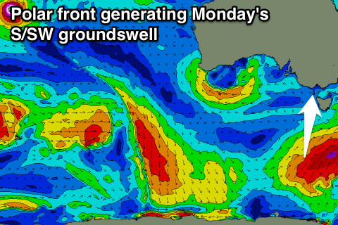
A strong pulse of S/SW groundswell that was on the cards for Monday has been downgraded with the vigorous polar frontal system firing up under the influence of the Long Wave Trough now forming a touchy further east than ideal and in the shadow of Tasmania.
Instead we're looking at a small increase to 3ft through the day across the Surf Coast and 4-5ft on the Mornington Peninsula under light variable winds again, creating clean glassy conditions before a SE'ly sea breeze kicks in.
Tuesday will be best east of Melbourne with the S/SW swell easing from 3-4ft and a smaller 2ft on the Surf Coast under N/NE winds.
Come Wednesday the Mornington Peninsula will be the only option as the swell bottoms out and winds persist from the N/NE.
There's nothing major on the cards then until late in the week, and that will be in the form of an inconsistent but moderate sized long-range W/SW groundswell.
This swell should then be followed up by a couple of stronger and more consistent W/SW groundswells into Sunday and then possibly Tuesday all linked to a strong node of the Long Wave Trough moving in from the west later next week, but more on this Monday. Have a great weekend!
Comments
Hi Craig,
So will tomorrow be clean in the morning, will it be offshore? And what time is it looking like it will turn southerly
Thanks
Yeah with that light variable wind it should be clean and glassy, but possibly slightly wobbly and lumpy. Not sure on the offshore but a good possibility.
Onshores probably starting to increase from 10:30-11am.
Nah I reckon St Kilda bay will be smoking for the rest of the winter. Why travel?
You could be onto something. The bay pumps!
http://hoaxcoast.tripod.com/port_phillip.htm