Best Saturday morning

Victoria Forecast by Craig Brokensha (issued Wednesday 11th March)
Best Days: Dawn around Torquay Thursday, Saturday
Recap
A strong pulse of SW groundswell filled in yesterday coming in at 3-5ft across the Surf Coast and a larger 6ft+ on the Mornington Peninsula under light variable breezes creating clean good waves across both regions. Weak sea breezes surfaced into the afternoon, but selected spots still offered fun waves.
A slight drop back in size was seen today but the Mornington Peninsula was still a solid 6ft+ and conditions were clean across both regions with morning offshores. A swing in winds to the NW through the day and then W/SW mid-late afternoon. So get out sooner rather than later.
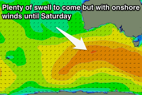 This week and weekend (Mar 12 - 15)
Moderate amounts of SW groundswell are due to persist through tomorrow and Friday from continued strong frontal activity through our swell window the last couple of days. The final front is this progression is still to our south-west today and will push across Tassie through tomorrow afternoon.
We should see the Surf Coast holding in the 3ft+ range with 3-4ft sets Friday, while the Mornington Peninsula should hold around 6ft tomorrow, with 6ft+ sets Friday.
Unfortunately winds are looking poor with a fresh SW change pushing through around dawn tomorrow, while Friday will see moderate to fresh S/SE winds in the wake of the change.
The only window of workable conditions will be early tomorrow around Torquay when a short-lived W'ly may be seen.
The weekend will see better waves as Friday's swell starts to drop away but from a good 3ft on the Surf Coast and 5-6ft on the Mornington Peninsula. An early N/NE'ly is due across locations east of Melbourne with N/NW winds on the Surf Coast. A shift to the NW is due during the day ahead of a late onshore change, so get out through the morning/early afternoon.
Sunday will then be poor with fresh S'ly winds in the wake of Saturday's change and smaller amounts of swell.
Next week onwards (Mar 16 onwards)
A small pulse of new S/SW swell for Monday has been downgraded but we should see some better S/SW swell impacting the state from later Tuesday and more so Wednesday and Thursday.
This will be generated by a couple of weak fronts firing up along the polar shelf over the weekend, and while the strength won't be there, the back to back nature of each system and their favourable position in our swell window will help produce some fun size.
The Surf Coast should pulse to 2-3ft later Tuesday with 4-5ft sets on the Mornington Peninsula, persisting through Wednesday before dropping back Thursday. Winds are a little unsure and might be from the S'th, but we'll review this on Friday.
Comments
Hey craig
do you think westernport will be even better this saturday
thanks