Good Friday morning, really fun over the weekend

Victoria Forecast by Craig Brokensha (issued Wednesday 4th March)
Best Days: Friday morning west of Melbourne, Saturday on the Surf Coast, Sunday morning both coasts, Monday morning Surf Coast
Recap
Yesterday was OK around Torquay with a small clean swell under light offshore winds, while further east conditions were bumpy and average.
A new SW groundswell built through the afternoon though with 3ft sets showing across the Surf Coast and larger 4-5ft waves on the Mornington Peninsula. Winds remained relatively light onshore around Torquay providing fun waves for an arvo paddle.
This morning the swell was holding around 2-3ft on the Surf Coast and 4-6ft on the Mornington Peninsula as we fall in between swell pulses, and conditions were great west of Melbourne with morning offshores.
A stronger increase in W/SW groundswell is due into the late afternoon though across both coasts, building to 3-4ft on the Surf Coast and 6ft+ on the Mornington Peninsula, with the odd 5ft set likely at swell magnets west of Melbourne on dark. Winds should also hold from the W/NW favouring a late surf.
This week (Mar 5 - 6)
This evening's kick in W/SW groundswell will be followed by a larger pulse of SW swell tomorrow as a strong frontal system projects up and into us today, producing a fetch of strong to gale-force SW winds on top of an already active sea state.
This should see the Surf Coast increase to 4-6f through the day tomorrow with 8ft+ sets on the Mornington Peninsula, but conditions are looking poor with a strong but easing SW change due to push through right on dawn.
This will also negate the chance of an early W'ly land breeze across the Torquay region, such is the timing and strength of the change. Best chance is for an early W/SW'ly around Torquay, but keep your expectations low.
Friday should reveal plenty of size with more favourable conditions through as a third frontal system is directed up through our swell window tomorrow afternoon and evening, keeping 3-5ft waves hitting the Surf Coast most of the day and 6-8ft sets on the Mornington Peninsula.
Winds should be offshore from the W/NW Friday morning around Torquay before swinging W/SW late morning, but don't dawdle. The Mornington Peninsula will remain poor with W/SW winds all day.
 This weekend onwards (Mar 7 onwards)
The SW swell should drop through Saturday from 3-4ft on the Surf Coast and 6ft+ on the Mornington Peninsula and winds will be even more favourable with a NW'ly across the Surf Coast, swinging W/NW'ly late morning and then W/SW through the mid-late afternoon.
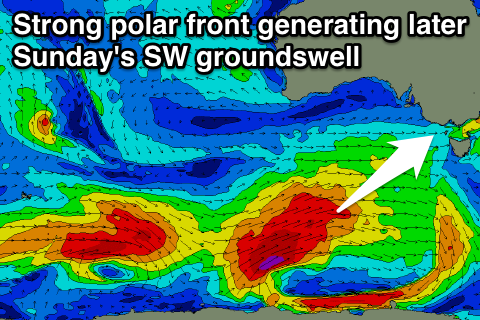
The surf should continue to ease into Sunday morning and winds will be even better with a N/NW'ly ahead of a shallow SW change mid-afternoon. A new good SW groundswell should build through the afternoon though generated by a strong polar front swinging in from the Indian Ocean, generating a fetch of gale to severe-gale W/SW tending SW winds.
The Surf Coast should kick to 3-4ft late in the day with 6ft to occasionally 8ft sets on the Mornington Peninsula, but with as touched on above, that onshore W/SW wind. A drop in size is due into Monday, with a very large long-period groundswell showing on the charts having no additional size, with it being generated in our far swell window near Heard Island.
The Surf Coast should be in the fun 3ft range though with morning offshore NW winds, with the Mornington Peninsula coming in around 6ft, but a strong SW change is due late morning.
This change will be related to another strong pulse of SW groundswell due Tuesday, with the front linked to the change developing east of Heard Island, projecting slowly north-east towards us while generating a fetch of SW gales.
We're probably looking ay 3-5ft and 6-8ft surf respectively Tuesday but winds will likely be average and onshore from the S'th in the wake of Monday's change. We'll have a closer look at this on Friday though.
Comments
Will those winds clean up the surface from the day before around PI?
Which day is that WarHawk?
Yes that would help. The saturday morning. All forecasts i'm reading are showing primarily westerly and strong
At this early stage it looks to be moderate to fresh W/NW early, easing and possibly tending NW through the morning, so a mid-morning paddle looks the go. Should become nice and clean under this scenario.
Mid-morning is good, driving down from melbourne so i get a bit of a sleep in haha. Fingers crossed. Cheers
Report from MC, swell kicking in nicely!! www.instagram.com/mcsurfboards
"New growing swell. 3-4+ at last we have our season back. Not good for Queensland when Victoria has good waves. Next week looks even bigger and better not so good for Queensland"
Just an update, the front generating tomorrow's reinforcing SW groundswell is now a touch stronger than forecast yesterday.
We'll now see 4-6ft waves across the Surf Coast all of tomorrow and winds are looking nice early to mid-morning and from the W/NW.