Easing surf with windows of favourable winds

Victoria Forecast by Craig Brokensha (issued Wednesday 25th February)
Best Days: Early Thursday Surf Coast, possibly Friday morning both coasts, Saturday morning exposed coasts
Recap
The swell kicked as expected yesterday with 3-4ft sets on the Surf Coast and 6ft+ waves on the Mornington Peninsula but under a poor and fresh to strong S'ly breeze.
Today the swell was easing as a new SE windswell filled in across the Surf Coast under strong E'ly winds. This opened up a few more options in protected spots to the east of Melbourne.
This week and weekend (Feb 26 – Mar 1)
Into the end of the week we'll continue to see the surf back away, although this easing trend will be slowed a touch through tomorrow as a small reinforcing W/SW swell fills in.
Size wise the Surf Coast should be easing from 2ft+ tomorrow and then down from a small 2ft Friday morning. The Mornington Peninsula should ease from 3-5ft tomorrow and then 3-4ft Friday.
Now, winds tomorrow will only be favourable for the Surf Coast for a short period during the morning with an early W/NW'ly ahead of a shallow SW change through the mid-late morning.
Friday is now looking dicey with a lingering onshore S'ly breeze in the wake of Thursday's change, creating average conditions across both coasts. There is still an outside chance of a variable breeze during the morning, but keep an eye on local wind observations for signs of this.
Saturday morning will be the best time to surf over the weekend at exposed breaks across the state with offshore N/NE winds and a small and inconsistent swell. The Mornington Peninsula is only due to be in the 3ft range during the morning with tiny 1ft+ surf west of Melbourne with improving conditions as winds tend more N/NW through the day.
A late afternoon and strong SW change is due, with poor and strong S/SW winds persisting into Sunday along with a small kick in windswell.
 Next week onwards (Mar 2 onwards)
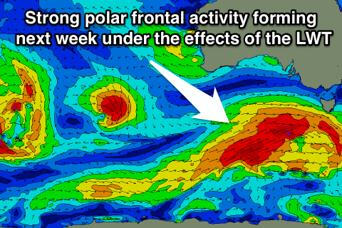
As touched on in Monday's update the outlook for next week is much more active as a strengthening node (peak) of the Long Wave Trough is forecast to move in from the west over the weekend and push slowly across us through Tuesday and Wednesday.
This will result in an increase in storm activity in the Southern Ocean, with a series of strengthening polar fronts being projected closer and closer towards us, climaxing in the strongest system through Tuesday/Wednesday. This should produce building levels of swell, likely peaking around the middle of next week, but we'll look closer into this on Friday.