Stacks of easterly swell ahead

Sydney, Hunter and Illawarra Surf Forecast by Ben Matson (issued Monday 15th February)
Features of the Forecast (tl;dr)
- Steady E'ly swells all week, and into the weekend
- Moderate onshores Tues/Wed (pockets of light winds)
- Better conditions Thurs onwards, light and variable in general
- E/NE swells becoming large Mon
Recap: Early Saturday morning offered a window of light winds north from Sydney; a S'ly change having pushed through Wollongong just before 6am. SE swells were still managing 3-4ft sets but once the wind swung, conditions deteriorated. Sunday provided wobbly waves with a mix of building S'ly and easing SE swells and fresh southerly winds. Fresh southerly winds have persisted today - in fact they have strengthened - as S'ly tending S/SE swells have built across the region from 3-4ft to 4-5ft.
This week (Feb 16 - 19)
We've got a week of topsy-turvy east swell, and variable conditions - initially bumpy and onshore, but slowly improving later.
Essentially the synoptics are in a blocking patterm with a stationary high pressure system south-east of Tasmania, and a broad region of low pressure across the Coral Sea and South Pacific.
Between the two is a broad, pulsing E'ly fetch, and small low pressure centers along the top of the trough line are forecast to move westward throughout the forecast period, squeezing the pressure gradient and tightening the fetch. This will create a number of embedded E'ly swells for the East Coast.
Exactly which coasts see the most size will be dependent on the alignment of each squeeze, and the strength of the embedded winds.
The first E'ly surge is developing in the central Tasman Sea as we speak, and will build surf size from later Tuesday into Wednesday, however it's best aimed towards Northern NSW so we'll see a smaller percentage of size across Southern NSW.
Tuesday will therefore see an initial easing from today's swell (mainly S'ly), easing from 3-5ft at exposed beaches, before rebuilding to a similar size through Wednesday with more east in its direction. Onshore breezes will persist from the SE though they should moderate a little, which may allow for isolated regions of light variable winds for short periods in the morning. Don't get your hopes up for any major quality though.
Thursday will see the primary swell direction swing E/NE thanks to a mid-week alignment within the Central Tasman fetch, though there'll be a secondary SE swell in the water from a secondary low developing off the SW tip of New Zealand's South Island this evening. Wave heights of 4-5ft look likely at most open beaches, and the synoptic onshore breeze should throttle back a little more convincingly to become light and variable through the morning.
Similar conditions are then expected to persist on Friday, though the SE swell will ease back. Model guidance suggests a general dip in size on Thursday and then a rise later Friday, though it's really hard to isolate specific trends, as we're essentialy looking at an entire week of overlapping swell trains. So it's quite hard to be confident in the exact phase of each swell train.
This weekend (Feb 20 - 21)
On the balance, the weekend looks pretty good. Persistent coastal troughiness should maintain generally light variable winds both days. Although the models have a gradual easing of size through Saturday, and a small uptick on Sunday, I think they're undercalling things: by Friday we will have had an entire week where almost the entire Tasman basin will have been active, pushing close to a 'fully developed sea state' (for the corresponding fetch). This means we're more likely to see wave heights motoring along in the 3-5ft range both days, just from Friday's status alone.
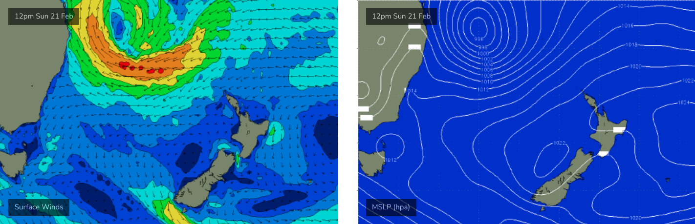
But at the same time, late Friday is expected to see a new low pressure trough develop off the SE Qld coast and push southwards, evolving into an impressive mid-latitude low pressure system. Strengthening E/NE winds on its southern flank on Saturday will generate the start of a stronger groundswell due to peak early next week, and we should see this in the water at some point on Sunday - so at this stage I can't rule out late 6ft+ sets.
More on this in Wednesday's update.
Next week (Feb 22 onwards)
The subtropical low to our north-east will reach a peak later Sunday or Monday (see below(, and this should generate solid E/NE swells in the 6ft to maybe 8ft range for Monday. Early indications are for continuing light winds under a weak pressure gradient, though at a week out this estimation requires some elasticity.
The slow moving nature of the low should ensure sizeable surf persists through TUesday before easing Wednesday onwards.
So, plenty of options to pick and choose from.
See you Wednesday!
Comments
Stacks of swell tonight
Winds 50-70km SSW; Sydney wave bouy 3-5m SSE
Good weekend ahead; thanks for the update.
Yeah lots of size out and about the various exposed reefs and beaches.