Variable summer swells short term; long term looking more like spring

Sydney, Hunter and Illawarra Surf Forecast by Ben Matson (issued Friday 1st January)
Features of the Forecast (tl;dr)
- Slowly building surf over the weekend, biggest on the South Coast, easing Monday
- Generally onshore breezes all weekend but with pockets of light variable winds
- S'ly change developing Tues, persisting at strength through Wed/Thurs
- Strong S/SE swells mid-late next week, holding through the weekend as winds ease
Recap: Small leftover surf has maintained peaky 2ft sets at most open beaches over the last few days. Light to moderate SE winds eased back to under 10kts late Thursday morning and through the afternoon, but have begun restrengthening this morning. As such conditions aren’t terribly flash today. A small increase in windswept is possible later.
This weekend (Jan 2 - 3)
Coastal troughiness will persist for the next few days, maintaining generally onshore winds across the region. There’s been a slight downwards revision in wave heights since Wednesday's notes, owing to a slightly weaker (modeled) easterly infeed through the central/western Tasman Sea.
The broad wind trend will hold from the E/SE on Saturday, and then the N/NE on Sunday, the latter of which may become quite gusty, and the dominant swell direction will match the wind direction, albeit with a lag.
That being said, the trough is expected to be quite complex with a new axis forming near the Illawarra on Sunday, before the broad system pushes offshore into Monday. What this implies is that we may see localised regions of light, variable winds at times.
I’m very hesitant to make any specific recommendations, as the models usually don’t resolve these patterns very well (spatially, or geographically) but if I were to hedge my bets, most regions south from Sydney should do OK for short periods throughout Saturday, whilst Sunday's benefits may be limited to a smaller region between the South Coast and Southern Sydney.
As for size, Saturday should rebuild from 2ft up to 3ft through the day out of the east, and wave heights should persist around this range through Sunday. There’ll also be a small undercurrent of E/NE trade swell in the mix, and Sunday will see some new NE windswell build throughout the day, of a similar size.
South from the Illawarra, Sunday’s developing trough should enhance wind speeds and we should see bigger waves by the afternoon along the South Coast, potentially 4-5ft (though more likely wind affected). But I'm still doubtful we’ll see much more than 3ft+ or so north from Sydney, as the strongest winds will be generally aimed south from here.
Next week (Jan 4 onwards)
Light variable winds are most likely on Monday as the South Coast trough/low pushes further off the coast. A southerly breeze is possible across southern regions, though the main wind strength from this development will push across the South Coast overnight Monday, reaching Sydney, Hunter and Illawarra coasts Tuesday morning (initial SW winds in a few locations veering fresh S’ly sooner rather than later).
There’ll be a complex mix of swells in the water early next week too.
Monday has a small SE swell on the cards from a low pressure system off the SW tip of New Zealand’s South Island this weekend. We’ll also see lingering trade swell (E/NE) from a ridge across the northern Tasman, local NE windswell from Sunday’s N/NE fetch off the Mid North Coast, and E/SE swell from the southern flank of the weekend’s coastal trough.
How big? Crunching the combined values from four sources is inherently difficult but let's peg most open beaches around the 3ft mark, with bigger (leftover, easing) waves along the South Coast from Sunday’s developments.
Most of these swell sources (except the E/NE trade swell) will then ease into Tuesday, but the southerly change will generate bumpy 3ft+ short range windswell by the afternoon, for south facing beaches.
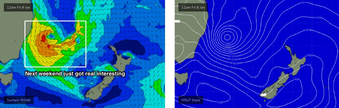
In fact it now looks like this trough/low in the lower Tasman Sea will remain slow moving for quite a days, and will dominate the rest of the week with gusty S’ly winds expected through Wednesday and Thursday, and potentially quite a bit of size. Yes, it’ll be wind affected but Thursday could see a peak in the 4-6ft range at south facing beaches.
Local conditions for the middle to latter part of next week don’t excite me much, but next weekend is looking much better as we should see the local pressure gradient gradually relax - allowing winds to ease - and persistent low pressure across the Tasman Sea (possibly in the form of a more significant Tasman Low, see below) should maintain strong, sizeable S/SE swells for quite a few days.
More on this on Monday. Have a great weekend!