Tricky conditions, with small flukey swells from many directions

Sydney, Hunter and Illawarra Surf Forecast by Ben Matson (issued Wednesday 10th June)
Best Days: No great days, but there'll be waves most of the time. Probably Sunday for the cleanest conditions, with a small mix of swells.
Recap: Tuesday saw a fun peaky E’ly swell across most open beaches with wave heights in the 2-3ft range. Size held overnight into this morning from Sydney to the Hunter, but eased slightly south from Sydney, and we’ve also seen a small undercurrent of south swell fill into the mix. Tuesday's winds were light so conditions were clean, the only exception being the Hunter which saw periods of onshores associated with a trough to the north. This morning was clean everywhere with light winds, but freshening E/NE winds associated with the trough have chopped up many locations this afternoon, and also built some local NE windswell.

Messy afternoon in Manly
This week (June 11 - 12)
*This week's Forecaster Notes will be a little sporadic, and sometimes brief, as Craig is on leave*
Small surf will persist for the rest of the week, with variable conditions under a weak trough.
This afternoon's freshening E/NE winds will ease overnight, and should become light and varaible by Thursday morning. A shallow southerly change is expected to push along the coast on Thursday afternoon and may linger into Friday morning but no major strength is likely. But, there's certainly a risk of adverse conditions across all coasts at times thanks to the unstable troughy pattern.
A high pressure system in the Tasman Sea extends a broad ridge from New Zealand longitudes through to the mainland, and is generating a building E’ly swell for Northern NSW that will spread down into southern NSW over the coming days. No major size is likely across our region, but occasional 2ft, maybe 2-3ft sets out of the E/NE will be found at exposed beaches on Thursday, easing a touch into Friday.
A northerly fetch has temporarily developed off the coast today and is generating local windswell for Southern NSW but it’ll fade into tomorrow as the winds ease.
We’ll also see some southerly groundswell across south facing beaches tomorrow, generated by intense though poorly aligned polar lows south of the continent over the coming days. Inconsistent 2-3ft sets may be found at south swell magnets, mainly the Hunter region though I’m less confident on this swell source than I was on Monday, as it hasn’t shown particularly strongly today. Southerly energy will fade into Friday.
And lastly, a long range E/NE groundswell is expected to arrive on Friday, generated by a strong bit distant storm in the South Pacific last week, near Tahiti. It’s unlikely this swell will punch above the pre-existing mid-range E/NE from the northern Tasman Sea ridge.
This weekend (June 13 - 14)
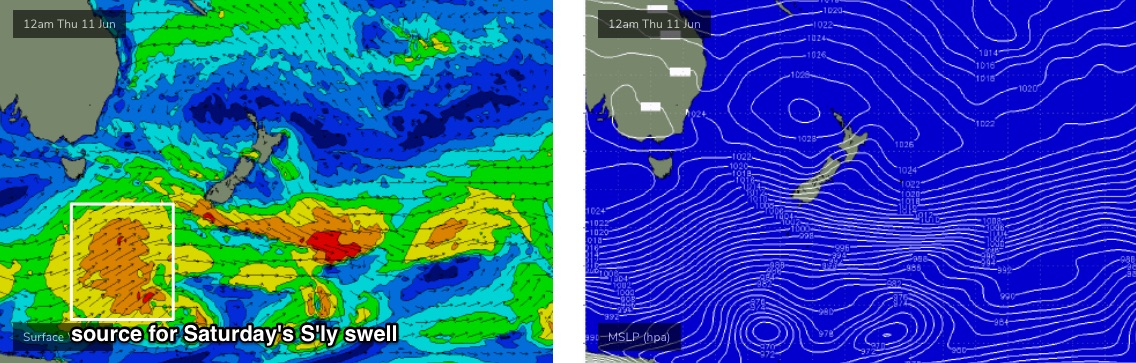
The latest model guidance has marginally strengthened another strong Southern Ocean front pushing below Tasmania today and tomorrow (see below).
As such, the resulting swell - due to build throughout Saturday - is a little more confident though the poor alignment of this system within our swell window means it’ll only favour south facing beaches with extremely inconsistent 2-3ft+ sets, a little bigger through the Hunter. This swell will then ease slowly through Sunday.
Elsewhere, and we’ll see small persistent E/NE swells from the Northern Tasman ridge both days, with size around 2ft. The long range E/NE groundswell may still offer a few waves early Saturday morning but isn’t expected to last long and will fade throughout the day.
Saturday still looks a little suss on the surface with freshening pre-frontal northerly winds ahead of a gusty W’ly change sometime on Sunday morning. The northerly fetch off the coast will broaden considerably during Saturday and extend a healthy distant up off the North Coast, so we should see a small additional NE swell on Sunday, mixing in to provide peaky 2ft waves at most open beaches.
Next week (June 15 onwards)
The Northern Tasman Sea ridge will strengthen a little into the weekend and so we’ll see a continuing undercurrent of small E/NE swell through the start of next week with inconsistent 2ft sets at open beaches.
More prominent on the synoptic chart is a pattern of strong fronts through the Bight and across the SE corner of the country. They’re going to generate very large waves for SA and Victoria, however the latest model guidance suggests the storm track may in fact be a little more zonal than previously indicated, which tilts these systems away from our swell window.
It’s a cruel blow, as it means we may not see any appreciable south swell until the very end of next week or the weekend.
There’s still a chance that Southern NSW will pick up small glancing south swells from the broader progression, and there’s also an outside possibility that the model guidance may swing back in our favour over the coming days - but right now we’re looking at another week ahead of small flukey swells from peripheral sources.
More on this in Friday’s update.
Comments
Better than nothing..