Nothing of note till Thursday

Southern Tasmania Forecast (issued Friday 4th Jul)
Best Days: Saturday away from Clifton, Monday at exposed spots
Recap
Tiny surf has persisted the last day or so and there wasn't too much on offer this morning either.
This weekend onwards (Jul 5 onwards)
Tomorrow's 1-2ft S/SW groundswell, mentioned Wednesday originating off a small but favourably aligned polar front pushing towards the Southern Tasman Sea is still on track, but winds are looking poor with a NE tending fresh E/NE breeze. This will favour locations away from Clifton (which will be terrible).
Into Sunday there's not expected to be any decent swell leftover and tiny waves will continue into next week. There's the chance for a distant and secondary sneaky SE groundswell for Monday to 1ft to maybe 2ft, but I wouldn't bet on it.
As touched on last update, the longer term is much more interesting as a strong node of the Long Wave Trough moves across the south of the country and then across us next weekend.
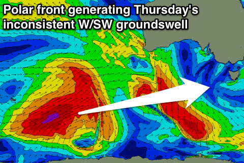 This should see the westerly storm track shift focus from WA and SA, around to us into next weekend, with a solid swell more than likely. Before this though, some distant W/SW groundswell should arrive for Thursday and offer some good waves across Clifton. Unfortunately a front passing through may bring an onshore change, but we'll review this Monday.
The bigger stuff is due next Saturday and at this stage looks to come from the SW and in the 3-4ft range, but we'll have to confirm this on Monday, so check back then for another update. Have a great weekend.