Fun weekend south swell in Northern NSW; remaining tiny in SE Qld

South East Queensland and Northern New South Wales Surf Forecast by Ben Matson (issued Friday 20th May)
Best Days: Sun: fun south swell across Northern NSW with light winds (there'll be some new south swell on Sat but winds are a little dicey north of Yamba). Don't expect much in SE Qld. Tues: building south swell in Northern NSW. Wed: large south swell across Northern NSW, only small inn SE Qld. Thurs/Fri: moderate, easing S'ly swells, best suited to Northern NSW.
Recap: Tiny waves for the last few days with mainly light winds.
This weekend (Saturday 21st - Sunday 22nd):
We’re still on track for some good southerly swell across the Northern NSW coast this weekend, but if you’re located north of the border, expect a disappointing round of surf once again.
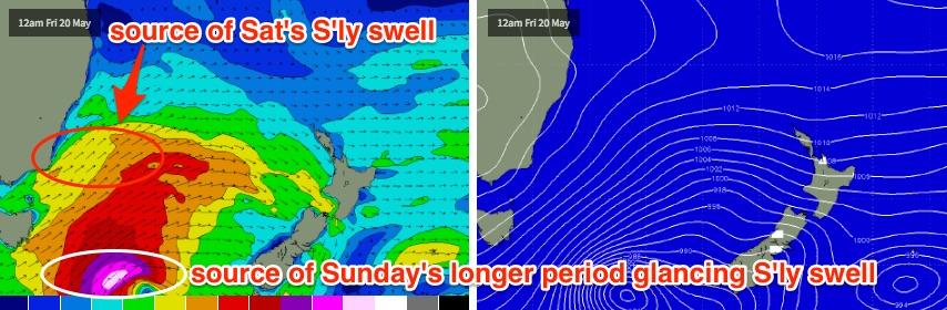
The new south swell is already making its way into southern NSW today (4ft+ sets and building), however there’s a couple of components to this swell event unfolding across the East Coast.
Most of the current energy we’re seeing down south has originated from the W/SW gales existing eastern Bass Strait late yesterday and overnight. However the parent low to this frontal progression lies much further south - well to the S/SE of Tasmania, in the Southern Ocean - and it began to strengthen today, displaying a 40-45kt S/SW fetch that’s now rocketing up through the central/southern Tasman Sea.
Unfortunately, this fetch is not very well aimed for the East Coast - it’s aligned perfectly for Fiji and Samoa (the former will enjoy 12-15ft+ Cloudbreak on Monday) but in our neck of the woods we’ll see the outer fringes of this swell glance the East Coast.
As a result, Saturday will see a mix of swells in the water - some short range energy from the post-frontal fetch, plus later in the day, some very infrequent but longer period S/SE energy will start to push through.
The timing is very important too. The initial short range S’ly swell is expected to peak early Saturday (Mid North Coast, 3-4ft sets south facing beaches) and before lunch (Far North Coast) before trending down throughout the day. However the new long period energy is not expected to reach the Mid North Coast until after lunch or maybe early-mid afternoon (4-5ft sets at south facing beaches) - and it may not reach the Far North Coast until after dinnertime.
What does this mean? There’ll probably be a decent portion of the day where various parts of the coast are "between swells". That is, on the backside of the smaller short range event but still waiting for the new long period energy to arrive.
Estimating the precise arrival times of each phase is very difficult, especially when you factor in the highly erratic nature of south swells and the way they respond across the coast (solid at some beaches, flat at others).
Saturday also has some potential problems on the surface, with a weak ridge developing across the coast, that's expected to kick up a moderate S/SE breeze throughout the day. Most of the strength in the wind will develop from mid-morning onwards, and mainly located north of the Byron, but we are at risk for south facing beaches in Northern NSW - which will be picking up the most size - to become bumpy. So keep your expectations low.
As such Sunday morning is my pick for the weekend. The new long range groundswell should be well and truly in the water by this time, in fact it’ll probably be easing already across the Mid North Coast, following an overnight peak. I’m expecting early 3-4ft sets at south facing beaches here (down to 2-3ft throughout the day) but the Far North Coast should see 4-5ft sets early morning at south facing beaches between Byron and about Yamba. Again, expect a steady easing trend throughout the day - the biggest surf will certainly be at first light, becoming smaller with each passing hour.
And Sunday’s conditions look a lot better too with mainly light variable winds and sea breezes.
As a side note, the models aren’t picking up this secondary long period S/SE swell very well - if you look at the forecast model data, it has just one solitary swell train from the south - however there’ll be a clear difference between the two energies, as the current swell event will probably max out with peak swell periods around 10-11 seconds, whilst the second groundswell could reach 15-17 seconds. It’ll be interesting to see what the physical buoys end up recording.
For surfers in SE Qld, unfortunately it’s going to be a tiny weekend of waves once again. The only hope is that you can make your way to one of the region’s south swell magnets, which may see a few stray 1.5ft sets throughout Saturday, possibly nudging 2ft or maybe 2-3ft on Sunday - but I’m not hopeful for anything amazing. Most beaches will be very small indeed.
Next week (Monday 23rd onward):
The low responsible for the weekend’s swell is expected to stall and meander broadly across the New Zealand region later this weekend and early next week. It’ll anchor a broad SW fetch off its West Coast, but unfortunately this looks generally out of alignment for our region.
That being said, the models have several related polar lows developing south of the South Island over the weekend, becoming absorbed into the broader flow. At the moment they don’t look overly promising for swell but there is a chance that they could swing in our favour. If this were to happen we could be looking at a flukey mid-week SE groundswell (say, Tues or Wed) but we’ll take a closer look at that on Monday.
Otherwise, we’ll be kicking off the new week with tiny residual energy from the weekend, only favouring south facing beaches under a moderate NW breeze. A ridge through the Coral Sea will be too far north to be of any benefit to the Southern Qld coast.
Surf prospects beyond this look pretty good though, but once again mainly for Northern NSW.
A vigorous front is expected to cross Bass Strait on Monday, and then stall in its eastward movement - mainly due to the “blocking” effect of the broadscale low across the NZ region.
And this is a good thing, as it’s expected to consolidate the front into a mid-latitude low E/SE of Tasmania, before slingshotting it up through the western Tasman Sea - almost due north in direction. Core wind speeds are expected to reach 50kts+, but this time round it looks like it’ll be aimed right into the NSW coast. Sure - straight southerly, almost S/SW in direction - but the effects on wave heights will be much more pronounced than the weekend’s south swells.
At this stage Tuesday is expected to see building southerly swell originating from the broad SW fetch extending north of the low. This will initially be short range energy, and accompanied by fresh SW winds, but south facing beaches across the Mid North Coast should reach 3-5ft by late afternoon (expect much smaler surf early). This swell may not reach the Far North Coast until overnight.
Wednesday morning is where the long period energy from the low is expected to make landfall, and at this stage it looks like south facing beaches in Northern NSW could pick up 6ft+ sets from this source. Beaches not open to the south will be much smaller though, around 3-5ft, with 2ft surf inside protected southern corners.
Of course, the extreme southerly swell direction will result in a massively wide variation of size depending on your beach’s exposure to the south, but this does look like being a pretty powerful swell event.
The good news is that we can also expect winds to back to the W/SW in the morning, allowing clean conditions across most coasts, except the Hunter which is often overly-exposed to these synoptic patterns. I'll take a closer look at the data on Monday to see how it's all tracking.
Unfortunately, it’s all bad news for SE Qld surfers as this swell direction rarely favours much size across the region. Small peelers are possible across the outer points in the 2ft+ range around Wednesday but even that’s a generous estimate right now. South swell magnets will probably be your only saviour throughout this period, unless you can tee up some highway miles south of the border.
The outlook after Wednesday is for surf size to ease steadily from the south, but not dramatically: the same low responsible for Wednesday’s surf is expected to continue the recent theme of NZ occupation: maintaining a modest southerly fetch over the eastern Tasman Sea that’ll probably continue to punch out moderate S/SE swell through the rest of the week and into next weekend too.
Have a great weekend, see you Monday!
Comments
I'll take 2 to 3 foot on the Sunny Coast. Thanks Ben
Lol dreaming.
The surf report on the local news was saying 3 to 4 feet Sunday. I think that's definitely dreaming. 2-3 is just being optimistic lol. I'll take 2 foot tomorrow. Any biggers a bonus
Might only be one or two beaches though...
Nothing happening in SE Qld but south facing beaches south of Byron are picking up plenty of south swell this AM.
Nothing around the Tweed Coast, lumpy mess. Fuck. Waste of time driving in, around. Fuck. Should have gone down to the Lennox Ballina stretch. Tomorrow, straight down, 110kmh all the way from the border... Bring on the bacon and egg rolls!
"... potential problems on the surface, with a weak ridge developing across the coast, that's expected to kick up a moderate S/SE breeze throughout the day. Most of the strength in the wind will develop from mid-morning onwards, and mainly located north of the Byron..."
Ya spot with that around here Ben. Was up early, messy lumpy yuck from dawn and never looked like settling.
Solid and overhead at Tweed backbeaches. Yeah the onshore is up but it's not too bad... A day like this back on the South Oz Mid Coast would be 8/10!
Any revision for surf for Tweed for tomorrow first light Ben?
No changes to Friday's forecast for any region.
Cheers Ben
Serious? Its fucking lumpy onshore junk and you'd give it an 8/10. Fuck, I know where freeride is getting his concern about the observed reports and rating. Most would struggle to give it a 1\10 on the Tweed Coast today. Its absolute junk...
Like I said, I should have spent the time on the highway and maxed the opportunity just south of byron. Would love to know what its doing down there today. I'm guessing by freeride s and others silence they are scoring good waves... Bastards.
It's only a 3/10 for the Tweed. Reference to SA Mid Coast won't make much sense unless you've lived there for a while.
Strong lines at Coffs, this looks like the new long period SSE swell.
Scored good waves north of evans south of lennox today. I figured i was at the right spot cause bobby martinez was putting on a fucking show. Checked a heap of spots on the way home and it was literally quarter the size windy as shit and packed as all buggery.
Dont make the same mistake tomorrow wingnut. Just gun it down early. Even though it was better as the tide dropped out.
Hmmm, I can pretty well GUARANTEE you all to get absolutely smoking fucking waves tomorrow... Ya see, I've fucked my back again today while moving furniture / packing up shit for new carpet being laid on Monday, so, yep, I'm out, you'll all fucking score! Not just tomorrow but the next few weeks too...
Fuck. Fuck. Fuckity. Fuck Fuck...
Hey Wingy,mate when your back settles down get into some light yoga and pilates.......
Cheers Simba. My routine of surfing everyday has worked well. It was one twist n lift, momentary lapse in concentration, and twinge, fuck, ah shit... Stupid thing, I'd lifted, moved bookcases, beds, and a heavy as fuck sofa bed, but, it was the office chair that I was shuffling into a storage nook, and it got caught, so I stupidly lifted and twisted it to get it to fit. Luckily the heavy stuff was all but done, and my BIL was here, so he got stuck in putting a stanley knife through the carpet, pulled it up, while I did the shuffle of taking it downstairs and loading it into my ute. The ongoing movement did it good... Not as sore or weak this morning as I had thought it would be...
it was pretty average and crowded as fuck Wingy, half of SEQLD was down here.
you didn't miss much.
Could've been worse FR, there were a few fun ones and the water was magic.
Still not worth driving down from Qld for!
When you consider how flat its been for the last 2weeks it was worth the drive
Damn!
Still very strong out of the S/SE at Coffs. Should be a good morning ahead in Northern NSW.
Out to see what I'm missing... Ah, not much. Pretty lumpy swell, fattish on the outer banks and the SE winds fluffing it's way up the open beaches already. Personally, I'm feeling ok. Not missing much at all!
Another disappointing sth swell for the tweed coast. This area just doesn't like, handle, these long line sth swells. Crappy long shore outer banks don't help either.
Clean solid 4ft sets, light winds, looking unreal right across the coast.
It's only small, but lots of lines are making their way down the Superbank.
Yesterday was the flattest and messiest it's been in this 2 week flat spell. Today was somewhere above flat but still rubbish. The only joy is seeing the faces blowins make after their long drives to arrive at a lake. Has to end sometime... right?
You're on the Sunny Coast, right Sprout? Surprised northern ends didn't pick up something. Based on the Snapper surfcam grab I would have expected 2-3ft sets at the northern end of the Goldy today and maybe something similar up your way.
Yeah mate, slightly bigger than yesterday but not hard to go up from flat haha. Lucky to be a 2fter Kings to Mdore from what I saw. Mates at DI said 2ft and windy. Hopefully not another week of it to come, doesn't look great though. Just looking at my log from last year, end of May/start of June was quite similar for no swell. Sunrise swims have been beautiful lately though.
Had heaps of fun today.
Got a spot in mind tomorrow. Looked sizey today, but wrong wind.
Interesting stats on the buoys from the weekend, especially when you factor in how the surf panned out. Couple of quick points:
Peak swell periods from Sat's first mid-range S'ly swell reached 14.5 seconds at the Gold Coast buoy, but only 13 seconds at the Tweed buoy.
Peak swell periods on Saturday's long range pulse reached 18 seconds at both buoys around the same time, but the signal was much fainter at the Tweed buoy (only one data point reported between about 1am and 6am - however the Gold Coast reported many.
Peak swell periods through Sunday afternoon dropped to 13 seconds at the Tweed buoy but remained as high as 15 seconds at the Gold Coast buoy.
Not sure on the reasoning for this but it's likely that the coastline (and the swell direction) is attenuating/filtering some of the energy, and that the long period energy that actually made its way 'round Point Danger was very small in size.
Not that you'd know, by comparing Hsig values.. only half to one foot difference throughout much of Sunday. Quite amazing considering Sunday was 4ft on the Tweed, and most of the Goldy was barely 1.5ft.
I'm down at the southern end of the GC at the moment. Yesterday at Snapper, around the middle of the day, there were head high sets. Not much zip, though.
Head high sets? Really? Didn't look much chop on the cams. Maybe just the first section at Snapper was picking up the size?
Yep. I was standing on a low balcony watching it. The sets weren't that frequent and the size didn't carry across Rainbow Bay. But there were some waves with an adult male standing fairly erect and wave height to the top of the head. I was a bit surprised, thought it was a freak set. But that set size recurred every now and then for an hour and half or so. As I said, not much power.
Best site for forecasts, onya Ben. Comically bad for surf reports though lol Maybe it's a good thing some folks not going to the beach after reading 2/10 ;-)
Wish I was out Carties 9ish Saturday night for this one haha.
extended Access G has something major, Major.
Holy shit Steve, that is significant for down your way.
that's an armageddon scenario for sure.
Shame it's the outlier of the models. Interesting too as Access has been performing well lately.
Yes mcsc, he's ok at this forecasting thing, hey?
Beats the old days of trying to analyse the synoptic chart in 10 seconds on the tv news weather report. Yeah, love the detail of the forecasts.