Improving week of winds and surf

South Australian Forecast by Craig Brokensha (issued Monday August 4th)
Best Days: South Coast tomorrow, Mid Coast Wednesday for the keen, Thursday both coasts, Friday and Saturday mornings South Coast, South Coast Sunday
Features of the Forecast (tl;dr)
- Large W/SW groundswell for tomorrow, easing Wed
- Fresh W/NW-NW winds tomorrow, S/SW-S/SE on Wed (S-S/SW on the Mid)
- Large SW groundswell Thu with light, local offshore winds, shifting SE
- Easing swell Fri with light, local offshore winds, shifting SE
- Moderate sized, reinforcing SW groundswell Sat AM, easing with light, local offshore winds, tending Ely
- Easing swell Sun with N/NE tending NW winds
Recap
The South Coast was the pick over the weekend with improving easing surf, best across the magnets into yesterday while bottoming out today.
This week and weekend (Aug 5 - 10)
We’ve got two, strong, back to back groundswells on the cards for this week, with the first coming in fairly west for tomorrow ahead of a SW swell through Thursday.
The first W/SW groundswell began production last Thursday night, with a strong polar low that fired up around the Heard Island region projecting towards Western Australia while slowly weakening. Initial storm-force winds eased as the progression moved north-east, with a large W/SW groundswell due to fill in through tomorrow, peaking during the day to 3ft on the Mid Coast with 4-5ft sets due off Middleton.
The remnants of this front will move in this evening, adding some weak mid-period swell to the mix tomorrow morning along with fresh W/NW-NW winds. This will favour the South Coast over the Mid Coast, with a slight drop in size due on Wednesday under S/SW tending S/SE winds as a trough moves through. The Mid Coast will be the pick with lumpy surf easing from 2ft+.
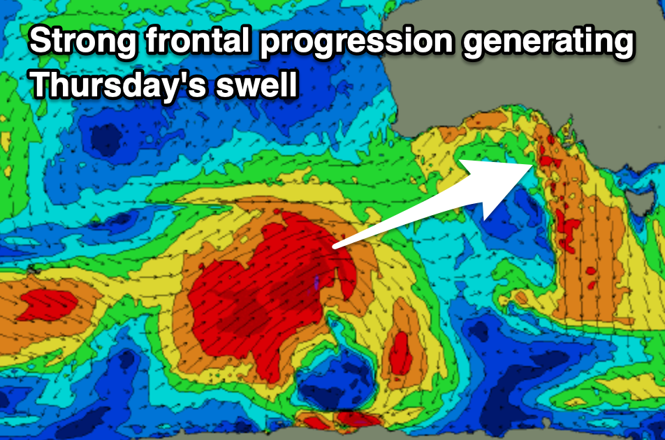
Moving into Thursday, a large SW groundswell is due to fill in, generated by a strong frontal progression that’s currently south-west of Western Australia. A great fetch of gale to severe-gale W/SW winds will be generated through our south-western swell window, weakening on approach tomorrow.
The South Coast should see 4-6ft waves off Middleton with the Mid Coast coming in at 2ft to likely 3ft on the favourable parts of the tide, and high pressure filling in from the west will bring variable offshore winds, shifting SE into the afternoon. This will favour the Mid all day, with Friday playing out similarly as the swell eases.
Come the weekend, a good reinforcing SW groundswell is due Saturday morning, generated by a weaker, trailing polar front behind the swell producer for Thursday. The Mid Coast only looks tiny and to 1-1.5ft with the South Coast offering the best waves, easing from 3-4ft during the morning Saturday, smaller Sunday.
Local offshore winds are due again Saturday morning with weak sea breezes, N/NE tending N/NW on Sunday as the swell fades.
Longer term there’s nothing too significant on the cards so make the most of this week and weekend.