Good west swell inbound with a great run for the South Coast

South Australian forecast by Craig Brokensha (issued Friday April 11th)
Best Days: Mid Coast this afternoon, both coasts tomorrow, South Coast Sunday, South Coast Monday morning, South Coast Tuesday and Wednesday, South Friday
Features of the Forecast (tl;dr)
- Moderate sized W/SW swell building this afternoon
- Moderate + sized SW swell for tomorrow, easing slowly Sun
- N/NE-NE tending variable winds Sat down South (E/NE early on the Mid), tending N then variable NW on the Mid
- Freshening N/NW tending NW winds Sun
- Small to moderate sized, inconsistent SW groundswell Mon with light, local offshore winds ahead of S/SE winds
- Small to mod sized S/SW groundswell Tue PM and Wed AM, with a small, reinforcing swell Thu
- Moderate N/NE tending variable winds Tue, N/NW tending W/NW Wed
- Variable N tending S winds Thu
- Moderate sized W/SW swell Fri with fresh N/NE tending N/NW winds
Recap
Our new pulse of S/SW groundswell filled in nicely through the day yesterday with the morning starting in the 2ft+ range across Middleton before pulsing to a great 3ft+ under all day offshore winds.
A trough brought an early evening onshore change yesterday and this morning we’ve got variable east winds as it clears and easing 3ft sets across Middleton.
The Mid Coast was wind affected and tiny yesterday, cleaner this morning but still tiny.
Into this afternoon a fun pulse of mid-period W/SW swell should build to 2ft across the Mid Coast with possibly weak sea breezes shifting S/SE-SE and strengthening later.

Great surf yesterday afternoon
This weekend and next week (Apr 12 - 18)
Today’s building W/SW energy will be reinforced by some stronger SW swell tomorrow, generated by a great, elongated fetch of strong to gale-force W’ly moving under the country the last couple of days.

The Mid Coast should hold 2ft on the favourable parts of the tide with 4-5ft sets off Middleton, easing slowly into Sunday from 1-2ft and 4ft respectively inside the gulf and down South.
Local winds look best for the Mid Coast tomorrow morning and light E/NE, though after tending more N’ly later morning, more variable NW winds into the afternoon should keep conditions relatively clean.
The South Coast should see a light N/NE-NE offshore through the morning, also tending variable into the afternoon.
Sunday is the pick of it though down South with freshening N/NW tending NW winds as the swell slowly eases.
Into Monday a very inconsistent long-range SW groundswell should slow the easing trend from the weekend, generated south-east of South Africa earlier this week by a strong polar low.

Middleton may offer very slow 3ft to possibly 4ft sets through the day before easing back in size Tuesday morning to 2-3ft. The Mid will also become tiny through this period. Morning variable winds should tend S/SE through the day Monday, with Tuesday looking great under a N/NE tending variable breeze.
Into Tuesday afternoon and Wednesday morning, an inconsistent but good S/SW groundswell is due, produced by a strong but poorly aimed fetch of gale-force W/NW-NW winds projecting towards the polar shelf through Sunday and Monday. A secondary small front looks to generate a smaller, secondary pulse for Thursday.
Middleton should kick to 3ft+ through the afternoon Tuesday, easing from 3ft Wednesday morning with Thursday only coming in at a slow 2-3ft. The Mid looks to miss out on this swell.
N/NW tending W/NW winds will create good conditions all day Wednesday, with Thursday looking dicier as a trough moves in bringing variable N tending S/SE winds.
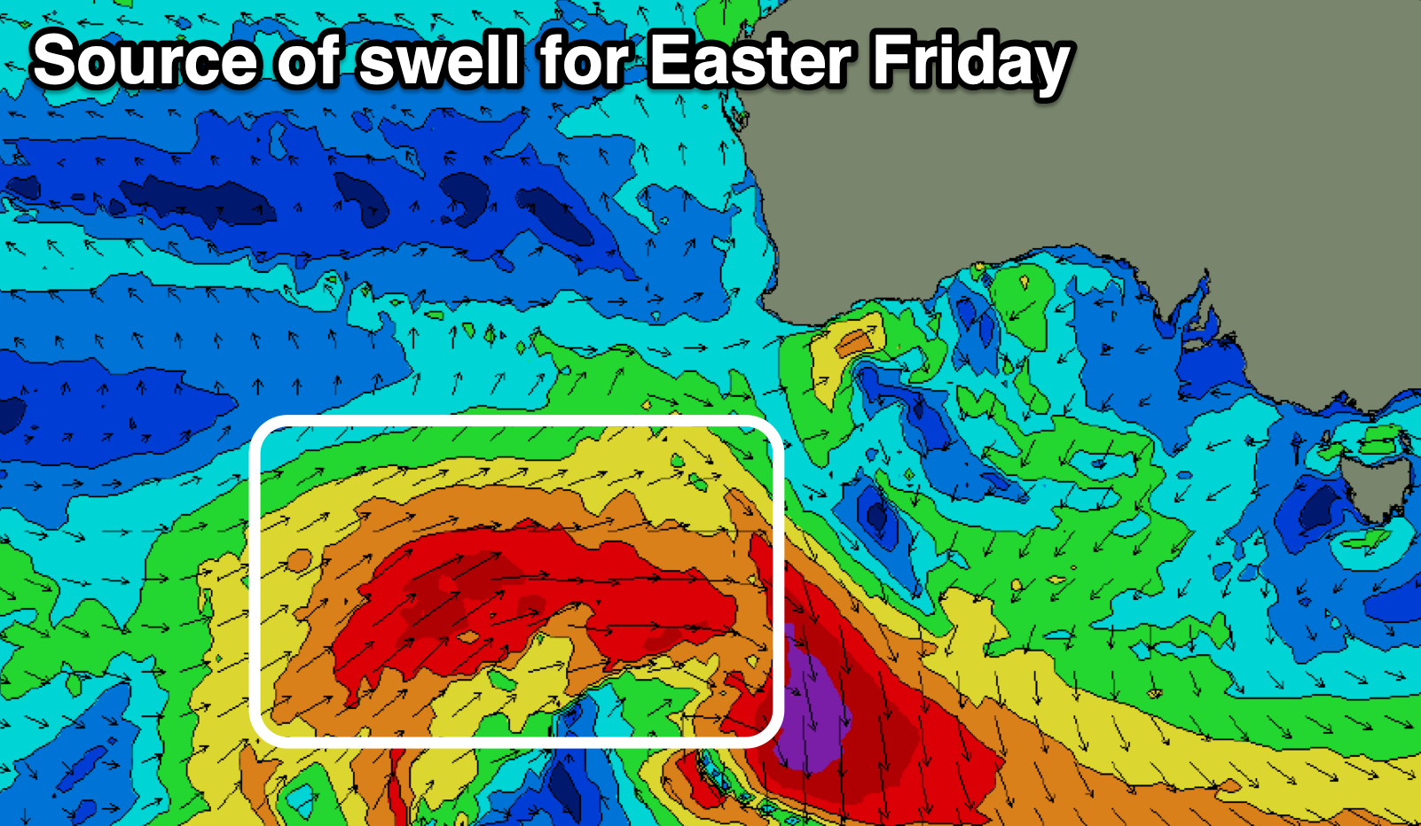
Now, moving into the Easter Long Weekend, we're set to see a good polar frontal system projecting up and under Western Australia early next week, generating a moderate sized though inconsistent W/SW swell for Friday.
The size looks to come in at 3-4ft across Middleton with 2ft sets on the Mid Coast under fresh N/NE tending N/NW winds. This will favour the South Coast again with easing surf under increasing W/NW winds likely Saturday.
Longer term the outlook is a little wishy washy into early the following week with some better frontal activity likely mid-late next week. Have a great weekend!
Comments
Any reliable information on the situation viz water quality on the Victor Harbor to Goolwa stretch after the cockle (pippi) and fish die off this week?
Plenty of red eyes and irritated throats getting around still. Flush your eyes afterwards and don't rub them.
Surfed Middleton 2 hours yesterday, first time in 3 weeks. Sore eyes and cough by arvo. Better today. Wish I had thought of rinsing the eyes instead of rubbing.
Surfed Saturday. Side affects worse. I think I will wait.
The "shark" at triggs was old mate black swan that's been cruising the mid for days now.
An interesting decoy. Has anyone proven that the swan is fauna and not machine?
There was an impressive wake trailing behind when I watched the footy.
Yeah looked like a swan to me.