This morning is the pick for the South Coast

South Australian Surf Forecast by Craig Brokensha (issued Wednesday February 22nd)
Best Days: This morning South Coast, beginners South Coast tomorrow morning, Mid Coast later Saturday and Sunday morning
Features of the Forecast (tl;dr)
- Fading, tiny surf tomorrow with strong N/NE winds, tending N/NW for a period into the PM, E/SE later
- Flat Fri with strong N/NE tending N/NW winds ahead of an evening SW change
- Moderate sized, inconsistent W/SW swell building Sat, easing Sun
- Early S/SE tending S/SW winds on the Mid, back S/SE later
- Moderate S/SE tending SW winds Sun
- Moderate sized SW groundswell building Mon, easing Tue
- Gusty SE tending S/SE winds Mon, S/SE-SE Tue
Recap
Poor surf across the South Coast yesterday with later Monday's pulse of SW groundswell easing, clean and windy on the Mid but easing from a slow, full 1-1.5ft.
This morning, winds have swung back offshore down South, cleaning up a peaky mix of S/SE windswell and easing mid-period S/SW swell with the Cape du Couedic showing the two seperate swells. Note the green direction swings and also period jumping between 7s and 12s.
It was quite raw early but now much cleaner, well worth a surf before winds go back onshore early afternoon.

Cape du Couedic data showing the mix of SSE and S/SW swells

Fun surf this AM
This week and weekend (Feb 23- 26)
Make the most of this morning's waves as we've got fading surf due into the end of the week, bottoming out on Friday.
Tomorrow will only likely be 1-1.5ft in the morning down South, flat on the Mid Coast but with hot, offshore N/NE winds that will last most of the day, even tending N/NW for a period during the afternoon before going E/SE late.
Friday will see stronger N/NE tending N/NW winds ahead of a trough and evening, cool SW change.
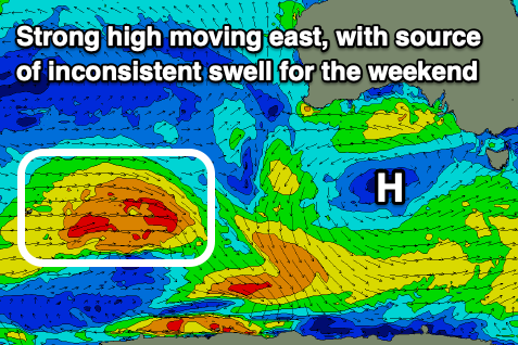
This change will be linked to a weakening, stalling low west of us in the Bight, with it due to be weak and slow moving once it pushes east across us on the weekend.
Unfavourable S/SW winds are due on Saturday with a building mid-period W/SW swell, improving on Sunday as winds shift S/SE through the morning.
The source of this swell was a healthy but distant low that formed in the Heard Island region, with a fetch of sub-gale-force W/NW-W/SW winds projecting east-northeast. The system is weakening today to the south-west of Western Australia, with the remnants forming the weak low in the Bight.
It'll be inconsistent but fun sets to 2ft are due on the Mid into Saturday afternoon, easing from 1-2ft on Sunday with the South Coast coming in at 3ft across Middleton, easing from 2-3ft Sunday.
Winds are likely to go S/SE later Saturday so keep an eye on that window, with Sunday being clean as discussed above.
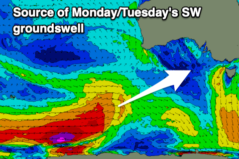
Winds will shift more SE into Monday, fresh in strength as a new, moderate sized SW groundswell fills in.
This should be generated by a stronger polar front firing up along the shelf, producing a great fetch of severe-gale W'ly winds. Middleton should build to 4ft on the sets, with the Mid Coast coming in at 1-1.5ft, easing slowly Tuesday from a similar size but with lingering S/SE-SE winds.
Unfortunately the rest of the week is likely to see winds from the south-eastern quadrant, maybe improving on Friday but check back here next update for a clearer idea.