Good Sunday, large swell for Monday

South Australian Surf Forecast by Craig Brokensha (issued Friday February 17th)
Best Days: Both coasts Sunday morning, Monday morning South Coast, later in the day Mid Coast, Mid Coast Tuesday morning for the keen, South Coast Wednesday morning
Features of the Forecast (tl;dr)
- Low point in swell tomorrow with light-mod S winds, increasing mid-late PM down South
- Small, inconsistent mid-period W/SW swell building Sat PM with a moderate sized pulse for Sun
- N/NE winds down South Sun AM, E on the Mid ahead of sea breezes
- Large SW groundswell building from late AM Mon, peaking in the PM, easing steadily Tue and Wed
- Moderate NE winds Mon AM ahead of sea breezes, with strong S/SE-SE winds on Tue
- Easing surf Wed with gusty E/NE-NE winds, tending E/SE winds
Recap
Great conditions with clean, inconsistent 2-3ft waves across Middleton yesterday morning, with 1-1.5ft sets on the Mid Coast as the heat built through the day. Winds freshened from the NW into the afternoon down South as the swell backed off a touch while the Mid Coast glassed off with an epic sunset lighting up virga (evaporating rain).
Today is cooler and onshore across the South Coast with poor conditions, glassy and lumpy on the Mid with slow 1-1.5ft sets.


Glassy waves yesterday AM and PM, with a sea breeze encroaching from top of frame on dark
This weekend and next week (Feb 18 - 24)
The start of the weekend looks poor, with a temporary low point in swell due tomorrow morning along with lingering, light to moderate S'ly winds across the South Coast, clean on the Mid but tiny.
Sunday looks much better as a moderate sized W/SW swell peaks, generated by back to back mid-latitude fronts pushing up and under Western Australia. The secondary front is strongest and currently pushing under the Bight, with the swell due to kick tomorrow afternoon/evening but peak through Sunday to a good 3ft+ across Middleton/Goolwa with 1-2ft sets on the Mid Coast working the favourable parts of the tide.
Conditions will be great across all locations with a light N/NE offshore wind down South, E on the Mid Coast with the afternoon becoming bumpy with sea breezes.
Monday morning will be clean again with NE offshore winds down South, E/NE on the Mid Coast, with sea breezes kicking in again ahead of stronger S/SE-SE winds on Tuesday as a trough slides in, followed by a strong high to our south-west.
Swell wise, the large SW groundswell mentioned in Wednesday's update is on track, with explosive cyclogenesis forecast to occur south of the country tomorrow. That being a low moving in from the west undergoing a rapid drop in central pressure, exceeding the required 24hPa within 24 hours to meet the 'bombing low' classification.
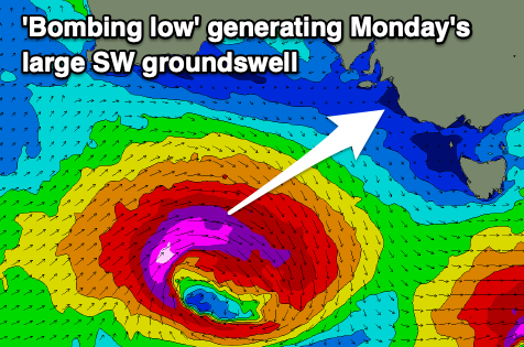
This will result in a rapid escalation of wind speeds with pre-frontal W/NW gales due to be followed by severe-gale to storm-force W'ly winds. This all sounds great but there's one slight issue, the fast track of the low to the east.
This will limit the size a little, but regardless we should see large sets building into Monday afternoon down South, pulsing to to 6-8ft down South with 1-2ft sets on the Mid Coast but with sea breezes, easing rapidly Tuesday from 4-6ft down South and 1-1.5ft on the Mid Coast with those poor S/SE-SE winds.
Winds will quickly swing back to the E/NE-NE on Wednesday morning, being fresh in nature but the swell will be weaker, easing mid-period energy out of the S/SW, dropping from 2-3ft across Middleton, near flat on the Mid Coast.
The swell will bottom out into the end of the week ahead of some new mid-period W/SW and SW swell next weekend, but a low forming in the Bight looks to bring winds out of the south-western quadrant. More on this Monday. Have a great weekend!