Oversized swell today, easing into the weekend as conditions improve

South Australian Surf Forecast by Craig Brokensha (issued Friday February 3rd)
Best Days: Novelty spots today South Coast, dawn tomorrow morning South Coast, Mid Coast for the keen tomorrow morning, South Coast Sunday, South Coast Monday morning for the keen
Features of the Forecast (tl;dr)
- Oversized S/SW groundswell peaking this afternoon, easing tomorrow
- Gusty SW winds tomorrow, likely W/NW at dawn around Victor (possibly light S Mid Coast)
- Fun moderate sized S/SE and S swells Sun AM, with an inconsistent SW groundswell for the PM
- Variable tending local offshore winds Sun AM ahead of slowly freshening sea breezes into the PM
- Easing SW groundswell Mon with E/SE-E/NE tending S/SE winds
- Smaller Tue with gusty S/SE winds
Recap
Decent waves in protected spots yesterday morning with plenty of size down South and strong W/NW winds. Conditions deteriorated into the afternoon with a strong W/SW change and building swell while the Mid Coast built rapidly to a stormy 4ft.
This morning the swell is very big and choppy down South with sets now pushing to 6-8ft but with a strong W/SW-SW winds. Novelty spots are the only option and the Mid Coast has dropped back to a semi-stormy 3ft+.

Chunky waves out the back of Knights (replacement cam on the way)
This weekend and next week (Feb 4 - 10)
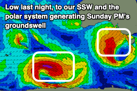
The cold polar low linked to the current weather and large surf is now weakening while continuing to project a fetch of strong to gale-force S/SW winds up and into us today.
A peak in S/SW swell is due this afternoon to 8-10ft but with strong SW winds, with a steady drop in size expected through tomorrow thanks to the low weakening and pushing east.
Locally winds will be generally gusty out of the SW down South and S/SW on the Mid, but there's a good chance for dawn W/NW breezes around Victor for a couple of hours and a less likely, light S'ly on the Mid.
Easing sets from 2ft to possibly 3ft are due on the Mid Coast with dropping 6ft to occasionally 8ft sets down South.
Sunday will become smaller but some reinforcing mid-period S/SE swell is due across the South Coast, generated by a fetch of strong S/SE winds wrapping around the southern flank of the low, to the south-west of Tasmania tomorrow morning.
Sets to 3ft to occasionally 4ft should continue, while the Mid Coast will become tiny. This mid-period swell will then be superseded by a new inconsistent SW groundswell into the afternoon, generated by a strong extra-tropical low that dipped south-east into the westerly storm track yesterday. A good fetch of severe-gale W/NW winds were produced to the south-southwest of Western Australia, with the swell building to an inconsistent 3-4ft across Middleton by late afternoon/evening, easing back from 3ft+ Monday morning.
Conditions look to become much cleaner across all locations Sunday with a variable breeze, tending locally offshore ahead of sea breezes which will only freshen from mid-afternoon. With this the South Coast looks worth a couple of surfs on Sunday.
E/SE-E/NE winds look likely Monday morning which isn't ideal but still workable for the keen, though Sunday will be much nicer and cleaner.
From Tuesday it looks like we'll return to normal summer programming with SE-S/SE winds and nothing major surf wise, so try and make the most of the coming windows of better conditions on the weekend. Have a good one!