Fun week of waves across the South Coast

South Australian Forecast by Craig Brokensha (issued Monday 15th August)
Best Days: South Coast tomorrow, Wednesday afternoon, Thursday morning, Friday morning, Mid Coast Wednesday
Recap
Great waves down South all weekend with small surf at Middleton Saturday, better out at Waits with the light W wind. Sunday was the pick though with a strong new W/SW groundswell filling in under all day offshores. The Mid was a lumpy 1-1.5ft Saturday with Sunday starting a little slow but kicking stronger through the day.
Today the surf was easing back from 1-2ft on the Mid with a northerly wind, while Middleton was a good clean 3-4ft. The surf has since eased but we may see a new long-period SW groundswell kicking on dark across the South Coast as winds tend variable from the N'th.
This week and weekend (Aug 16 - 21)
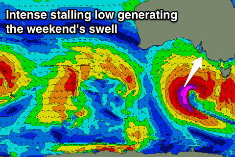
Later today's increase in SW groundswell was generated by an intense low firing up on the tail of the weekend's swell producing activity. Satellite observations confirm a fetch of severe-gale to storm-force winds just on the edge of our swell window.
This swell should keep Middleton kicking with 3-4ft sets tomorrow morning, larger at Waits and Parsons, easing back steadily through the day. The Mid Coast isn't due to see much size with 1-1.5ft sets, easing through the day.
Conditions will be best for the South Coast with a strengthening N'ly tending N/NW breeze.
Wednesday will start average but improve across the South Coast, with an onshore change due to move through later tomorrow. Early SE winds look to create average conditions but a shift to the E/NE is due through the day, possibly NE around midday/early afternoon and variable into the afternoon. Therefore aim for a surf from lunch onwards. The Middleton Cam will be the best indiciation for improving conditions.
Size wise the surf will be smaller, with a weak reinforcing W/SW swell keeping Middleton between 2-3ft, larger to 4ft+ at Waits and Parsons.
The Mid Coast will be clean all day but only around 1-1.5ft for the most part. If we're lucky later in the day we may see 2ft sets.
A drop in swell is then due Thursday down South with gusty N'ly winds, strengthening ahead of a late W'ly change.
 This change may kick up a late increase in windswell across the Mid to 2ft or so but with no quality.
The change will be linked to a developing low pressure system to our south with an initial fetch of strong to gale-force W/SW winds projected through the Bight expected to be followed by a fetch of severe-gale to storm-force S/SW winds directly south of us Thursday evening and Friday.
With this we should see an initial W/SW swell filling in Friday, coming in at 2ft to occasionally 3ft on the Mid, while the South Coast will see building surf to 3ft at Middleton under W/NW tending W/SW winds.
Moderate levels of SW swell are due to persist Saturday ahead of the S/SW groundswell proper later in the day, peaking Sunday. Size wise we're probably looking at 4-5ft sets across most breaks, with the odd bigger one possible at Waits and Parsons under N/NW winds. We'll have a closer look at this Wednesday though as the models are still yet to converge on the position and structure of the low.
Comments
A bit inconsistent but solid when the sets come..
That inside section was fun yesterday when the sets came through.
Not usually a Dribs fan, but when all else fails...
Yeah last time I was back home I had a ball out there, early morning sesh and only a few local lads out.