Fun weekend down South with an easing swell, good Mid swell next week

South Australian Forecast (issued Friday 27th November)
Best Days: Saturday morning, Sunday morning, early Monday swell magnets, Tuesday afternoon and Wednesday Mid Coast, Thursday morning both coasts
Recap
A good mix of new SW groundswell and windswell saw 2-3ft waves across the Mid yesterday but with onshore winds, while the South Coast also offered plenty of size with a building S/SW swell but fresh to strong S/SW winds.
Today, cleaner conditions were seen with light variable tending locally offshore winds and solid amounts of S/SW swell, best suited to Middleton and the Chiton stretch. The Mid Coast was cleaner but back to a smaller 1ft to occasionally 2ft.
This weekend and next week (Nov 28 – Dec 4)
 South Coast: The weekend's looking fun down South with a gradual drop in S/SW swell, from 3-4ft across Middleton and 4-5ft at Waits tomorrow morning, down further from 2-3ft and 3-4ft respectively Sunday morning.
Light offshore N'ly winds are due tomorrow morning, creating clean conditions ahead of an afternoon SW'ly, while Sunday morning should also be good with a more variable breeze, possibly tending light NE.
Monday will see a fresher offshore N/NE tending NW breeze kick in through the morning, ahead of a mid-afternoon W/SW change, but the swell will be minimal and lucky to be 2ft at Waits and Parsons on the sets, fading through the day.
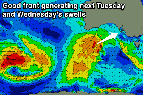
Into Tuesday a mix of small SW groundswell and building SW windswell will be seen across the South Coast ahead of a stronger increase in groundswell Wednesday.
The small SW swell will be produce by a small low currently just east of Heard Island, with small 2ft waves due across Middleton and 3ft+ sets at Waits early with W'ly winds.
A relatively weak but favourably tracking frontal system from the south-west of WA Sunday up towards us through Monday and Tuesday should produce an initial increase in SW windswell Tuesday afternoon as it pushes through with SW winds, followed by the stronger groundswell Wednesday to 3-4ft+ at Middleton and 5-6ft at Waits and Parsons.
Winds unfortunately look to remain onshore from the SW, while Thursday should be cleaner with a morning E/NE breeze as the swell slowly eases, softened by a smaller reinforcing SW swell. Friday looks cleanest with a morning NE'ly.
Mid Coast: Tiny clean fading surf is expected into the weekend, fading from 1ft tomorrow with nothing really left for Sunday.
Monday will start tiny, but the approaching front should bring an increase in W/SW windswell through the late afternoon but only to 0.5-1ft ahead of a stronger increase Tuesday afternoon to 2ft, with Wednesday holding in that 2ft+ range before easing back slowly through Thursday and further Friday.
Conditions could be fun Wednesday morning with an early S/SE breeze and then offshores from Thursday. Check back here Monday for an update on this and in the meantime, have a great weekend!