Large swells to kick of September

Bali and Mentawais forecast by Craig Brokensha (issued Thursday 1st September)
Best Days: Every day over the coming period
This week and next (Sep 2 – Sep 9)
Bali: Today is the start of a good run of SW groundswell energy across Indonesia.
The first pulse due today will be the least consistent, generated in our far swell window south-east of South Africa. We should see exposed breaks building to a strong but inconsistent 5-6ft through today.
A slightly more consistent pulse is then due Friday, produced by a secondary front piggy-backing over the top of the original system, but also pushing further into the central Indian Ocean.
Slightly larger and more consistent 6ft to occasionally 8ft sets are due across swell magnets ebbing and pulsing through the day tomorrow, holding Saturday morning and easing through the day.
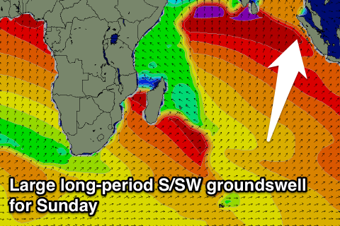
Our larger SW groundswell for Sunday and Monday has been generated in the central Indian Ocean, with a broad and vigorous polar front moving over an active sea state, projecting a fetch of severe-gale to storm-force W/SW tending SW winds.
This swell should build later Sunday and peak Monday morning, but ahead of it some new long-period energy is due ahead of it Sunday morning from pre-frontal W/NW gales ahead of the main low.
Good 6ft+ sets are due Sunday morning at exposed breaks, kicking to a larger 8ft to so into the afternoon, easing back from 8ft to possibly 10ft early Monday.
The swell will ease further through Tuesday from 6ft to occasionally 8ft, while a reinforcing S/SW groundswell is due Wednesday morning. This will be generated by back to back fetches of severe-gale W/NW winds to the south-west of WA, late in our swell window, and also working perpendicular to it as well.
 Still, exposed south facing breaks should see 6ft+ sets, easing back later in the day and more so from 5-6ft Thursday morning.
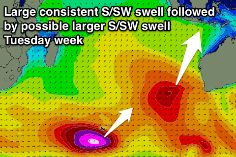
Now, as touched on last update, another large groundswell is on the cards for the following weekend, but this will be more a mid-period number, generated by a northward projecting front high up towards us early next week.
A large consistent S/SW groundswell will be generated, coming in at 8-10ft next Saturday across exposed breaks, with a possible larger long-period number to follow it Tuesday the 13th.
We'll have a closer look at these follow up swells next update though. Weak E/SE trades are expected tomorrow and Saturday, becoming moderate to fresh from Sunday through next week and the following week. Keep in mind early each morning local land sea breezes will overcome these trades.
16 day Bali Forecast Graph
16 day East Java Forecast Graph
16 day Sumbawa Forecast Graph
Mentawais: Today the first pulse of SW groundswell from under South Africa should be providing solid 6ft to occasional 8ft sets at magnets, with tomorrow's slightly stronger pulse pushing to a more consistent 6-8ft.
A temporary drop in size is then due ahead of Sunday's large and powerful S/SW groundswell (coming in more south across the Ments compared to Bali). Similar large 8ft to occasionally 10ft sets are are due into the middle of the day and afternoon, easing back from the 6-8ft range Monday morning.
 The reinforcing S/SW groundswell seen across Bali Wednesday isn't due to really impact the Mentawais, with the swell dropping back to 5ft or so at exposed spots.
The timing of next weekend's large consistent S/SW groundswell is similar to Bali, with a peak due Saturday morning to 8-10ft across exposed south facing breaks, easing into the afternoon and further Sunday.
Tuesday the 13th's longer-period S/SW groundswell won't be as big in the Mentawais, with it being generated along the polar shelf around the Heard Island region and south-west of WA, but we'll look over this again Tuesday.
Winds over the coming period are due to be generally variable, with a slight S/SE tendency tomorrow and N/NE tendency next Wednesday/Thursday.
16 day Mentawai forecast graph
16 day Nias forecast graph
16 day South Sumatra forecast graph