Indonesia/Maldives forecast Aug 8
Indian Ocean Basin analysis by Craig Brokensha (issued Thursday 6th August)
This week through next (Aug 9 - 16)
Our large, inconsistent SW groundswell kicked in nicely yesterday with western Indonesia seeing the swell earlier than Eastern Indonesia, with an increase seen into the afternoon across the east holding this morning.
The swell is expected to ease into tomorrow morning but we’ve got our large, reinforcing S/SW swell due into the afternoon/evening, peaking overnight and then easing Saturday, smaller Sunday and then reaching a low point Monday morning. Size wise it looks similar to the first but a little more south.

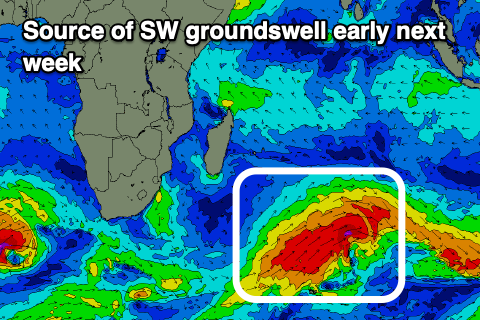
We then look at the large SW groundswell due for Tuesday, with northward positioned frontal progression linked to it currently sitting well north of the Heard Island region.
A great fetch of gale-force W/SW winds are being projected towards us, with a secondary intensification of SW gales projecting on top of the active state, closer towards us.
This should generate two pulses of large, consistent SW groundswell for next week, the first building Monday afternoon, peaking Tuesday morning with a secondary pulse for the afternoon.
The surf will then ease Wednesday, with a trailing front due to generate a large reinforcing S/SW groundswell for Thursday afternoon, easing Friday samll than that seen early week.
Longer term, the strong storm activity will continue with a large, long-period S/SW groundswell on the cards for the week starting the 19th. More on this next Tuesday.
In the Mentawais there’ll be some S/SE trade-swell also in mix later next week onwards thanks to an elongated fetch of E/SE winds setting up throughout the northern Indian Ocean, generating large surf for the Maldives, explained in more detail below.
----------------------------------------------
S’ly swell energy has been easing across the Maldives southern regions, with a reinforcing pulse today due to ease slowly tomorrow and more so into the weekend.

We then look at the large pulses of S’ly groundswell for later Sunday and more so Monday from the storms in the Indian Ocean.
This swell will likely be hidden under a renewal of S/SE trade-swell energy thanks to strengthening SE winds to our south over the weekend.
Moderate + sized levels of swell are due to develop into early next week, while an expansion of the fetch eastwards next week should generate even more energy through later next week and beyond.
The S’ly groundswell pulses look to also back off a bit from next week but check back here Tuesday for the latest.
Eastern Indonesia:
Large, reinforcing S/SW groundswell for later tomorrow, easing Saturday, coming in at 8ft on the sets across the magnets.
Large consistent groundswell building Monday afternoon, peaking Tuesday morning, with a secondary pulse for the afternoon, reaching 8ft across exposed breaks.
Reinforcing S/SW groundswell next Thursday afternoon/Friday morning to 6-8ft.
Fresh to strong E/SE-SE trades over the coming days, easing slowly from the weekend, and remaining fresh next week with lighter, more variable winds each morning.
Uluwatu 16-day Forecast Graph/WAMs
Western Indonesia/Mentawais/South Sumatra:
Reinforcing large S/SW swell tomorrow afternoon to 6-8ft, easing through the weekend.
Large SW groundswell building next Monday, peaking Tuesday to 8ft+ across the exposed breaks, easing Wednesday and Thursday.
Reinforcing S/SW groundswell later Thursday and Friday morning to 6ft.
Moderate to fresh S/SE-SE winds across southern locations most of the period (strong tomorrow and next week - weaker and more variable on the weekend), lighter across northern locations.
Mentawai 16-day Forecast Graph/WAMs
Maldives:
Reinforcing S’ly groundswell today to 3-5ft across the southern atolls, easing tomorrow.
Small SE trade-swell this week to 2ft+ across exposed breaks.
Moderate + sized S’ly groundswell building later Sunday to 4-5ft across the southern atolls, easing Monday from a similar size.
Moderate + sized S/SE trade-swell building Sunday, holding next week to 4-5ft+ across exposed breaks.
Larger SE trade-swell from later next week onwards more to 6ft.
Moderate W/NW winds across northern and central locations tomorrow and Saturday, S’ly to the south.
Lighter W/NW winds across northern and central locations early next week, variable to the south with winds strengthening across northern and central locations mid-late week, S’ly to the south.


Comments
Is it on?
Latest notes are live.
Nice waves today but it really ( as you forecasted ) was inconsistent at times with long long lulls then 6-8 wave sets . Only 4-5 ft on NL but expecting bigger tomorrow .
Same over in the east , solid pulses catching out those seeking the inside. Then big lulls luring the impatient back in. Easy double overhead on those sets.
Farking solid today
Yeah bit of extra south helping as well eh.
Definitely Craig , yesterday was a bit too much west in it and swell wasn’t getting into the strait but today was firing , got lit up on my last wave and called it a day , had some nice ones though .