Later Sunday and Monday morning the pick

Eastern Tasmania Forecast by Craig Brokensha (issued Wednesday 11th February)
Best Days: Later Sunday, Monday morning
Recap
The surf was tiny through yesterday, while today new levels of NE windswell were building down the coast with early favourable winds. Conditions deteriorated through the morning but have since cleaned up with a late offshore change, offering good waves across open beaches.
This week onwards (Feb 12 onwards)
An early morning S'ly change is expected up the coast tomorrow and with this we'll see the NE windswell back off from the 1-2ft range across north-east swell magnets, while a junky S'ly windswell will develop across south facing beaches to 2ft to nearly 3ft through the day.
Conditions will be poor though with a S/SE tending E/SE breeze.
This fetch will then swing E'ly through Friday off our coast, producing building levels of E'ly windswell but to a smaller than expected 2ft across open beaches through the afternoon. Conditions will be poor in any case with a gusty E'ly onshore wind.
 Come Saturday though the windswell should be bigger and peak through the middle of the day, as winds through our swell window reach a peak in intensity around dawn.
The Scammander region should see 3ft waves with larger surf to the south due to the fetch being aimed more into the south of the state.
Also in the mix should be a building E/NE trade-swell from the fetch of strong E/SE winds above New Zealand, extending into the Northern Tasman Sea.
The timing of this swell has been pushed back a touch with it due to arrive through the afternoon Saturday providing 2ft to occasionally 3ft sets across open beaches, persisting Sunday before easing Monday.
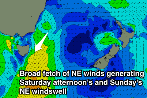
At the same time though stronger levels of NE windswell are due to develop Saturday afternoon as a broad fetch of NE winds develop to our north-east during Saturday and strengthen further Sunday.
This will likely see north-east facing beaches kicking to 3-4ft later Saturday and then possibly coming in at 3-4ft+ all of Sunday.
Winds will be poor and onshore Saturday from the E to NE but Sunday should see N'ly winds ahead of a late NW change.
This change will move the in-feed of NE winds generating the windswell away from us with a drop in windswell due through Monday from 3ft across north-east facing beaches under morning offshore W/SW winds.
Into Tuesday there isn't expected to be much swell leftover with background levels of E/NE trade-swell to 1-2ft or so.
Longer term besides small and inconsistent levels of E/NE groundswell from a possible re-strengthening of the trade-flow above New Zealand there's nothing to major besides the normal sporadic pulses of NE windswell. More on this Friday though.