Large swell building Friday, peaking Saturday with westerly winds

Java, Bali, Lombok, Sumbawa forecast by Craig Brokensha (issued Tuesday 21st April)
Best Days: Wednesday through Thursday exposed breaks, Friday through Saturday south-east facing breaks, Sunday onwards exposed breaks
 This week and weekend (Apr 22 - 26)
Our recent run of good S/SW groundswell is reaching its final stages, with a final pulse of inconsistent and more S'ly swell this morning, due to ease back through tomorrow and further Thursday, bottoming out into the evening.
Winds will become more favourable for exposed breaks and unfavourable for the name breaks with a light morning W/NW breeze Wednesday and Thursday, becoming stronger from the west on Friday before easing back Saturday and becoming more variable Sunday.
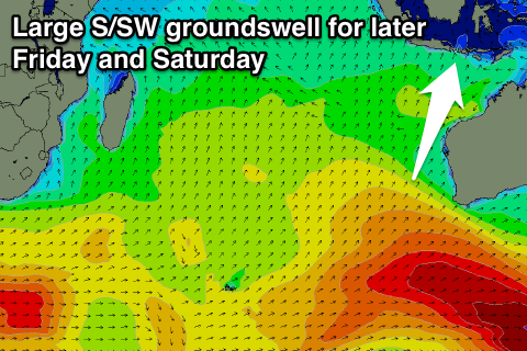
Into Friday though a large new S/SW groundswell is expected, generated over the weekend by a vigorous polar low that formed just west of Heard Island.
This low generated a fetch of severe-gale to storm-force W/SW winds while pushing east-northeast towards WA, with it moving out of our swell window, below Australia this morning.
An inconsistent but strong and large S/SW groundswell has been produced that should build through Friday and reach 6-8ft across exposed spots late in the day and peak Saturday morning to 6-8ft+. But remember normal breaks that work in the trades will be onshore with the W'ly winds, so a hunt around to east facing breaks will be the pick.
The swell should ease back slowly through Saturday afternoon and then down further through Sunday and Monday but this easing trend will be softened slightly by a couple of secondary weaker polar fronts pushing up towards WA on the tail of the main system.
Exposed spots should ease from the 6ft+ range Sunday morning and down further from 5ft Monday.
Longer term there's nothing significant due for next week with the swell due to bottom out through Wednesday afternoon and Thursday morning.
The charts aren't indicating any major frontal activity heading into the start of May either with small to moderate amounts of background swell due to keep exposed breaks active. We'll have another look at this on Thursday though.
16 day Bali Forecast Graph
16 day East Java Forecast Graph
16 day Sumbawa Forecast Graph