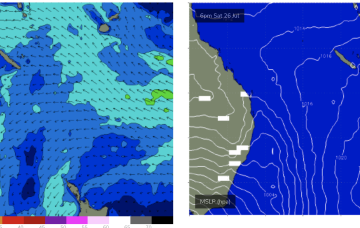
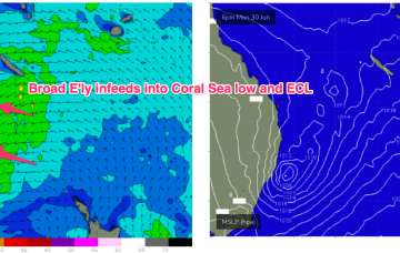
Good news though for next week with another powerful high expected to move through the Bight and set up a strong ridge up the QLD coast and deep E’ly-SE’ly flow through the Coral Sea.
Primary tabs
/reports/forecaster-notes/central-queensland/2025/08/11/easing-swells-week-more-surf-the-radar
freeride76
Monday, 11 August 2025
/reports/forecaster-notes/central-queensland/2025/08/01/tinyflat-surf-continues-small-waves-mid-next
freeride76
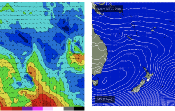
Friday, 1 August 2025
Late this week we may see another strong high move into the Tasman with a SE surge building up the coast and building swells Fri into the weekend, possibily getting sizey if a low pressure trough forms off the CQ coast.

/reports/forecaster-notes/central-queensland/2025/07/28/tinyflat-surf-continues-small-waves-mid-next
freeride76
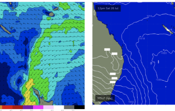
Monday, 28 July 2025
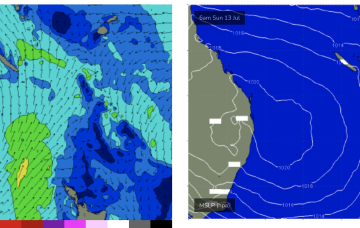
It’s a real monster of a system and we may see some long range SE-E/SE swell at spots open to the north of k’gari and the Breaksea spit with some 2-3ft sets through Tues and Wed.
/reports/forecaster-notes/central-queensland/2025/07/23/tiny-surf-continues
freeride76
Wednesday, 23 July 2025
Nothing of interest in the Coral Sea next week suggesting more tiny/flat surf.
/reports/forecaster-notes/central-queensland/2025/07/21/remaining-tinyflat-high-pressure-remains-sub
freeride76
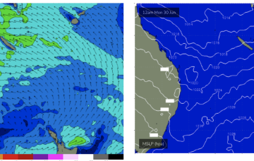
Monday, 21 July 2025
Tiny surf continues this week as high pressure remains in the Tasman with a low not quite in the swell window and swells too weak to get around K’gari (Fraser Is).
/reports/forecaster-notes/central-queensland/2025/07/16/remaining-tinyflat
freeride76
Wednesday, 16 July 2025
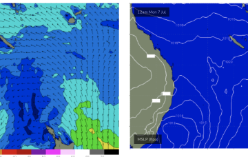
This won’t be well placed for CQ but we may see a rideable day as the low drifts away towards New Caledonia.

/reports/forecaster-notes/central-queensland/2025/07/09/winter-flat-spell-in-progress-no-end-in-sight
freeride76
Wednesday, 9 July 2025
We’re in a typical winter style pattern with the high pressure belt up over the continent and any SE winds are now confined to the tropics.
/reports/forecaster-notes/central-queensland/2025/07/04/tinyflat-surf-week-and-next
freeride76
Friday, 4 July 2025
Weak high pressure is drifting up over NSW/QLD with a low in the Tasman moving away to the east as it weakens. No signicifant swell generating winds in the Coral Sea so surf is tiny/flat and likely to remain that way right through the weekend and next week.
/reports/forecaster-notes/central-queensland/2025/06/30/tinyflat-while
freeride76
Monday, 30 June 2025
Winds in the Coral Sea feeding into the Coral Sea trough generate some fun waves for CQ. Those waves should continue into Tues before easing Wed as the trough/low dips southwards.
/reports/forecaster-notes/central-queensland/2025/06/27/fun-blend-over-the-weekend-continuing-next
freeride76
Friday, 27 June 2025
The initial infeed into the Coral Sea trough provides quality E/NE swell for CQ building Mon and holding Tues before easing.