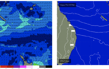
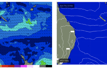
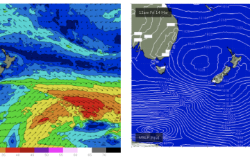
Weak high pressure is in the Tasman with a modest tradewind fetch in the Coral Sea with another weak high moving into the Tasman in it’s wake. Trades perk up today into tomorrow suggesting a small bump in size over the weekend into Mon before easing early next week.
Primary tabs
/reports/forecaster-notes/central-queensland/2025/03/14/small-fun-waves-low-tide-bump-little-over-the
freeride76
Friday, 14 March 2025
/reports/forecaster-notes/central-queensland/2025/03/12/few-small-waves-about-low-tides
freeride76
Wednesday, 12 March 2025
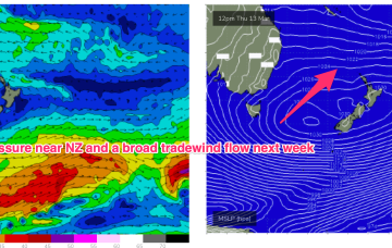
We should see fun waves up to the weekend, easing into early next week before rebuilding on the back of a SE surge Wed next week.
/reports/forecaster-notes/central-queensland/2025/03/10/small-swells-easing-then becoming-surfable
freeride76
Monday, 10 March 2025
High pressure drifts more NE into the Tasman with a weak trade flow sitting in the Central Coral Sea through the mid to end of this week.
/reports/forecaster-notes/central-queensland/2025/03/07/tiny-swells-becoming-surfable-next-week
freeride76
Friday, 7 March 2025
Anywhere north of the cyclone, especially north of Fraser (K’gari) will see vastly reduced surf.
/reports/forecaster-notes/central-queensland/2025/03/03/only-tiny-swells-now-alfred-the-south
freeride76
Monday, 3 March 2025
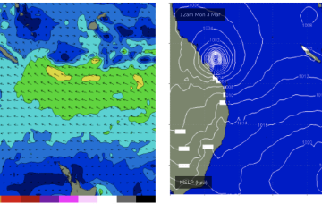
With the storm now south of Fraser (K'gari) we’ll see most of the swell blocked by that Island.
/reports/forecaster-notes/central-queensland/2025/02/28/pumping-cyclone-swell-tc-alfred-tracks-south
freeride76
Friday, 28 February 2025
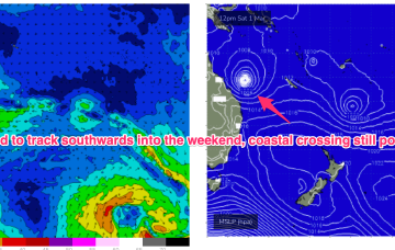
TC Alfred is about 730 KM NE of Rockhampton and expected to move southwards today, with a SW track possible into Sat.

/reports/forecaster-notes/central-queensland/2025/02/26/surf-likely-get-l-xl-tc-alfred-approaches-cq
freeride76
Wednesday, 26 February 2025
If we get the CQ crossing, very serious surf in the 8ft range or bigger is likely Mon into Tues.
/reports/forecaster-notes/central-queensland/2025/02/24/plenty-action-tc-alfred-moves-through-the
freeride76
Monday, 24 February 2025
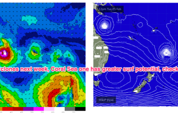
The trade-wind fetch is relatively robust and will be a long-lasting swell producer for the east coast, favouring sub-tropical areas for size. Confidence is low on the track for TC Alfred and thus it’s surf potential- a general slow southwards movement is expected which is favourable but we may still see a coastal crossing before the cyclone reaches it’s full potential as a surf generator.
/reports/forecaster-notes/central-queensland/2025/02/21/lots-surf-days-ahead
freeride76
Friday, 21 February 2025
Medium term surf potential rests on these tropical lows, with the supporting tradewind belt supplying plenty of energy in the interim, focussed on the sub-tropics.
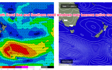
/reports/forecaster-notes/central-queensland/2025/02/19/rebuild-in-size-se-surge-arrives-fri
freeride76
Wednesday, 19 February 2025
We’ll see a brief fallow period before a SE surge Fri brings a new SE swell with the next round of Tradeswell next week, possibly enhanced by tropical low pressure systems in the South Pacific and Coral Sea.