On it’s own that will see a broad E’ly fetch develop likely in the New Caledonia quadrant, extending into the South Pacific slot. GFS adds to that recipe for a round of (sizey) trade swell with a deepening trough in the Coral Sea which spawns a surface low mid week, currently modelled to track southwards into the Tasman.
Primary tabs
/reports/forecaster-notes/sydney-hunter-illawarra/2025/06/13/easing-swells-over-the-weekend-tropics
freeride76
Friday, 13 June 2025
/reports/forecaster-notes/sydney-hunter-illawarra/2025/06/11/good-sse-pulse-tomorrow
Craig
Wednesday, 11 June 2025
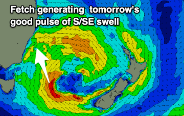
We've got a better angled pulse of S/SE energy for tomorrow with decent winds through the morning.
/reports/forecaster-notes/sydney-hunter-illawarra/2025/06/09/slow-moving-low-in-the-tasman-supplies
freeride76
Monday, 9 June 2025
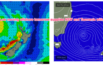
We’ll see the low move slowly out to sea later tomorrow and generate an initial pulse of local, directional S swell before moving further into the Tasman with better angled swells produced for later in the week.
/reports/forecaster-notes/sydney-hunter-illawarra/2025/06/06/fresh-offshores-and-fun-waves-weekend
freeride76
Friday, 6 June 2025
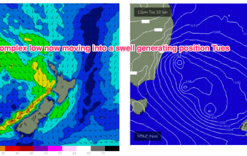
The story of next week is still a stalled low in the Tasman- although swell potential gets a major upgrade as the low gets moving Tues into a swell producing position.
/reports/forecaster-notes/sydney-hunter-illawarra/2025/06/03/raw-and-ragged-s-swell-short-term
freeride76
Wednesday, 4 June 2025
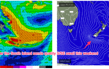
With the Tasman Sea inflamed by these robust S’ly fetches we’ll see strong S’ly swells in the short term, improving in quality as size eases from the proximate fetch and better quality swell trains fill in from below and adjacent to the South Island.
/reports/forecaster-notes/sydney-hunter-illawarra/2025/06/02/windy-and-sizey-s-swells-conditions
freeride76
Monday, 2 June 2025
The energy cranks right up Wed as strong winds to low end gales develop off the NSW South to Central Coast and into the Tasman.
/reports/forecaster-notes/sydney-hunter-illawarra/2025/05/30/south-groundswell-filling-in-over-the
freeride76
Friday, 30 May 2025
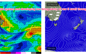
We’ve currently got a deep polar low with two strong embedded fronts tracking NE into the lower Tasman. High pressure moves up over NSW with easing pressure gradients while a trough deepens off the QLD coast and drifts south over the weekend.
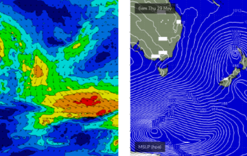
/reports/forecaster-notes/sydney-hunter-illawarra/2025/05/28/very-active-period-ahead-plenty-size-the
freeride76
Wednesday, 28 May 2025
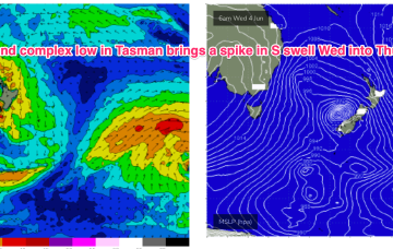
A strong cold outbreak has led to the formation of a winter-calibre low in the Tasman (984hPa), backed by a strong, slow moving high in the Bight. We’re seeing the formation of strong S swells from this system, which will peak tomorrow then ease with a following front and deep low well to the south providing a strong S groundswell over the weekend under light winds.

/reports/forecaster-notes/sydney-hunter-illawarra/2025/05/26/coupla-large-south-swells-ahead-plenty
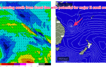
thermalben
Monday, 26 May 2025
We’ll see several different sources of swell from this system, most of which will overlap at some point so it’ll be hard to distinguish them all (and kinda pointless really, seeing how rapidly surf size will increase). But let’s take a look at a few of ‘em.
/reports/forecaster-notes/sydney-hunter-illawarra/2025/05/22/improving-conditions-plenty-swell-nor
freeride76
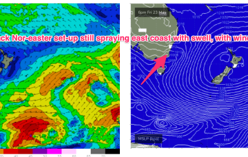
Friday, 23 May 2025
We’ll see plenty of swell from this low-carb nor-easter, with a slow easing trend over the weekend, more pronounced on Sun.