Good S/SE pulse tomorrow

Sydney Hunter Illawarra Forecast by Craig Brokensha (issued Wednesday May 11th)
Best Days: Today, tomorrow morning, Saturday morning, Sunday exposed coasts
Features of the Forecast (tl;dr)
- Moderate + sized S/SE swell pulse tomorrow with fresh W/SW tending S/SW winds
- Slight drop in S/SE swell Fri, slowly easing Sat and more so Sun
- Fresh to strong SW-S/SW winds Fri
- Moderate SW tending S winds Sat (W/SW early Northern Beaches)
- W/NW tending variable winds Sun
- Tiny most of next week
Recap
Building levels of mid-period S’ly swell were seen through yesterday across the Sydney region, coming in bigger earlier in Sydney and then filling in through the afternoon across the Hunter.
Wollongong and locations south saw SE energy spreading off a healthy fetch of E/SE winds as the base of the low sitting in the Tasman Sea, similar today with stronger levels of mid-period S’ly swell showing across the Newcastle/Hunter regions.

Sold new south swell today
This week and next (Jun 12 - 20)
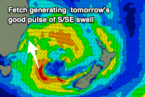
While the current energy is very south in direction from about Sydney north, we’re expecting a new mid-period pulse of S/SE swell tomorrow, generated by a good fetch of strong to gale-force S/SE winds projecting up towards us along the south-western flank of the Tasman Low as it slowly moves east.
This should provide a bit more size across open beaches, with south magnets coming in at 4-5ft across most locations (6ft sets magnets), while the Hunter and South Coast will see surf more consistent in this upper range.
The easing trend into Friday will be slow thanks to an additional fetch of strong SE winds forming off the southern tip of New Zealand’s South Island, maintaining 4ft+ surf through the day, easing slowly from a similar size Saturday morning, smaller and back from 2-3ft Sunday.
Looking at the local winds and tomorrow will be the cleanest day across the south magnets of the coming couple (though not perfect) with a fresh W/SW breeze, shifting S/SW into the afternoon as a small trough stalls east of us, with less favourable and strong S/SW-SW winds due Friday.
Winds should slowly ease but remain SW into Saturday morning (W/SW Northern Beaches) before shifting S’ly into the afternoon, then W/NW tending variable Sunday as the swell fades.
The outlook is slow into early next week with small to to surf expected thanks to our major swell windows falling quiet and remaining so until possible tropical activity in the Coral Sea later in the week. This looks mobile, tracking away from us so make the most of the current energy.
Comments
Hope it does pick up its pretty much been a non event so far.
Very disappointing when you look at the maps.
Swell looks good this morning.
5ft centy coast now
One of those two big for some too small for the other swells.. tomorrow with the easing of period the banks should handle better..
Thanks for the forecasts Craig.
Last three weekends have been good. Hopefully get some leftovers this weekend.
Pumping again this morning 4-6ft at our favourite south facing beach on the southern northern beaches (term from lockdown remember that when they divided the NB)
Nice!