Average weekend with easing swell, better early next week

Western Australian Surf Forecast by Craig Brokensha (issued Friday December 15th)
Best Days: Monday morning, Tuesday morning, Friday morning in the South West
Features of the Forecast (tl;dr)
- Easing surf on the weekend with fresh, devlepong E/SE winds tomorrow AM, strong S/SE-SE Sun AM with strong sea breezes each afternoon
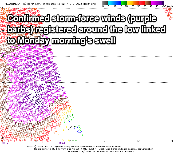
- Late pulse of long-period SW groundswell Sun, peaking Mon AM with fresh SE winds (E/SE at times) ahead of strong sea breezes
- Easing swell Tue with strong E/SE winds ahead of sea breezes
- Small, inconsistent mid-period SW swell building Thu PM, easing Fri with morning E/SE winds and strong sea breezes
- Moderate sized, inconsistent SW groundswell for next Sun with S/SE-SE morning winds
Recap
A slow drop in swell across the South West thanks to reinforcing pulses of swell, cleanish in the mornings ahead of sea breezes. To the north it's been clean but tiny.
This weekend and next week (Dec 16 - 22)
The coming weekend will be average for surf as the current energy fades away with developing E/SE offshore winds during the morning tomorrow, stronger S/SE-SE on Sunday.
We look to the large SW groundswell due into Monday across the state, with the strong polar low linked to this currently generating a fetch of severe-gale to at times storm-force W/SW winds. The low formed around the Heard Island region yesterday and will project east-northeast towards the Bight while weakening from this evening.
There's no real change to the expected size, with it likely showing later Sunday ahead of a peak Monday morning to 8-10ft across the South West magnets, 2-3ft in Mandurah and 2ft across Perth.
Winds look generally fresh and gusty out of the SE across all regions though we may see periods of E/SE winds before strong sea breezes kick in.
The swell will ease through the day and drop off steadily through Tuesday with strong but easing E/SE winds ahead of sea breezes. The South West looks to be dropping from 4-5ft max on the magnets, 1-2ft Mandurah and Perth.
Following Monday's swell there's nothing major on the cards at all until late week, when a small, inconsistent mid-period SW swell arrives.
Beyond this, a slightly stronger though distant low should produce a secondary pulse of groundswell for next Sunday but with slightly less favourable winds. More on this Monday. Have a great weekend!