Make the most of the current swell

Western Australia Surf Forecast by Craig Brokensha (issued Friday March 31st)
Best Days: Today in the South West, tomorrow morning in the South West, South West magnets Sunday morning
Features of the Forecast (tl;dr)
- Moderate sized, easing mid-period SW swell tomorrow with gusty but easing E/SE tending E winds ahead of mid-arvo sea breezes
- Smaller Sun with E/SE tending S/SW winds
- Inconsistent, moderate sized W/SW groundswell building Mon, peaking later, easing Tue
- Gusty S/SE tending stronger S/SW winds Mon, gusty S tending S/SW on Tue
- S'ly winds persisting through the end of the week with a new W/SW swell later Thu, peaking Fri
Recap
Windy, inconsistent and small 3-4ft waves easing through yesterday across the South West, tiny to the north and today, our new pulse of S/SW groundswell has come in under expectations across all locations.
It's clean but very slow and to 4-5ft across the South West, tiny to the north and looking at the Cape Naturaliste buoy there doesn't look to be too much to come from this initial pulse of groundswell. Winds should remain offshore all day though so it'll be worth an after work surf regardless.

Make the most of the current swell and conditions
This weekend and next week (Apr 1 - 7)
Seeing as today's swell came in a little under-cooked, tomorrow's reinforcing pulse of mid-period S/SW swell hasn't been effected, with it generated by a trailing fetch of strong to gale-force SW winds on the backside of the initial progression linked to today's swell.
We should still see 4-5ft waves across the south magnets in the South West, with Mandurah and Perth only likely to be 1-1.5ft.
Conditions will be great with an easing, gusty E/SE offshore wind with sea breezes due to kick in mid-afternoon.
Sunday will be clean again but on the small side as the S/SW energy continues to ease.
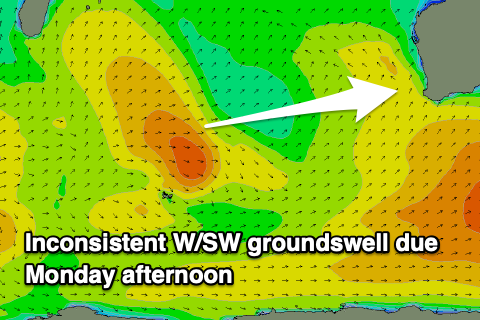
Moving into Monday and the swell will reach a temporary low point ahead of a new pulse of inconsistent W/SW groundswell through the afternoon, easing back slowly through Tuesday.
The source of the swell was a strong, slow moving but tight mid-latitude low that formed to the south-southeast of Madagascar this week.
It'll be very inconsistent but we should see surf building to 4-6ft by dark on Monday in the South West 2ft in the sets in Mandurah and 1-2ft across Perth. Winds will be an issue though with a trough due to swing winds S/SE on Monday morning ahead of the swell and then gusty S/SW through the afternoon.
The trough looks to linger Tuesday, forming into a low in the Bight bringing poor, gusty S'ly winds as the swell eases. So all in all not great.
Swell wise, some inconsistent mid-period W/SW-SW swell is due later Thursday but more so Friday but to no major size and with average S'ly winds. So all in all not great and it'll be worth making the most of the current swell today and tomorrow.