Good swell mid-week with average winds, larger swell for Sunday

Western Australia Surf Forecast by Craig Brokensha (issued Monday 20th June)
Best Days: Perth Thursday morning, Margs early Friday morning, both coasts early Sunday
Recap
Workable waves in protected spots across the South West Saturday morning before winds tended more N'ly through the day. Perth and Mandurah were cleaner but tiny and fading from 1-1.5ft.
Sunday was poor with small to tiny leftovers across all coasts and deteriorating conditions.
Today a new W/SW swell has provided a touch more size across all regions as average conditions persisted.
This week (Jun 21 - 24)
Some new SW groundswell energy is expected across the region this week, the biggest and best for later Wednesday and Thursday morning but with generally average winds.
Firstly tomorrow a new SW groundswell should produce some better 3-5ft sets across the South West, with tiny 1ft waves around Perth. Onshore S/SW winds will persist across the South West though with a better SE'ly to the north.
Wednesday will see winds continue from the W/SW across the South West with more variable winds to the north and similar amounts of swell.
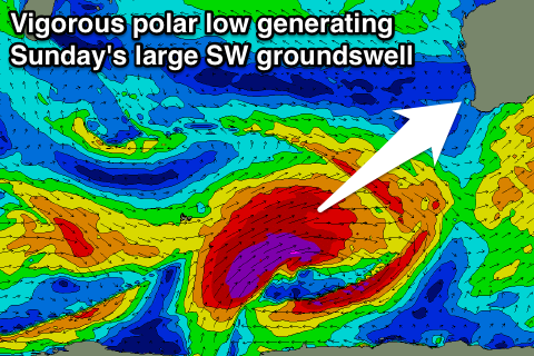
Into the afternoon some new long-period SW groundswell is due, with it starting to be generated over the weekend by a vigorous polar low firing up in the Heard Island region.
A fetch of severe-gale W'ly winds were generated, with the system since projecting north-east towards the Bight. A moderate to large SW groundswell is expected, kicking later Wednesday to at least 6-8ft, peaking overnight and easing from a similar size Thursday morning.
Perth may see 1-2ft sets on dark, but Thursday will show better size to 2ft, easing through the day.
Unfortunately winds on Thursday across the South West will continue from the S/SW (possibly swinging S/SE later in the day) with SE tending S'ly winds around Perth.
Friday will be cleaner across the South West but the window limited with a dawn E/NE'y due to swing more N/NE and then NW into the afternoon with an approaching front. Perth will remain offshore for longer.
This weekend onwards (May 20 onwards)
 Saturday isn't looking to offer anything meaningful with leftover amounts of swell and lingering onshores, improving late.
Of much greater significance is a very strong polar low firing up in the Heard Island region tomorrow evening.
A fetch of severe-gale to possibly storm-force W/SW winds will be projected ideally up towards us and then towards the Bight into the weekend, generating a large powerful long-period SW groundswell for Sunday. The swell may be seen on dark Saturday but a peak is due Sunday morning to a large 12-15ft across the South West (larger at offshore bommies) and 3ft+ in Perth.
At this stage conditions are looking OK early but will deteriorate through the day as an approaching mid-latitude low steers a dawn E/NE'ly around to the N/NW through the day while freshening. We'll confirm this Wednesday though.