Average outlook with limited windows

Western Australia Surf Forecast by Craig Brokensha (issued Friday 27th November)
Best Days: Tuesday morning, Wednesday morning swell magnets
Recap
Cleaner conditions and a slight kick in S/SW swell across the South West yesterday while Mandurah and Perth remained tiny.
Today the swell was small and choppy with a fresh SE wind in the South West, only 0.5ft further north.
This weekend and next week (Nov 28 – Dec 4)
Small average surf will continue tomorrow with SE to S/SE winds, while Sunday also looks poor with a very slow start and S/SW winds. An afternoon kick in new small SW swell is due but there'll be no decent options.
Monday's better SW groundswell should see exposed spots building from 3-4ft to 4-5ft later in the day along with average S-S/SE winds. Perth isn't expected to build above 1ft.
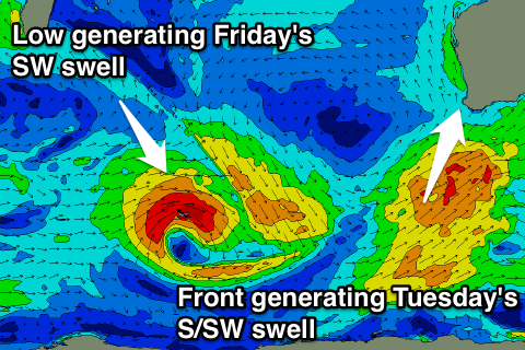 Into Tuesday a similar sized 3-5ft of S/SW swell is expected across the South West from a weak polar front pushing up towards the Bight, on the edge of our swell window.
Better winds are expected with this swell but, offshore from the E/SE, and this looks to be the best day of the week and worth making the most of.
Wednesday will also be clean with an offshore E'ly, but the swell will be fading from a small 3ft or so.
Later Thursday and more so Friday morning another small SW groundswell is expected from an unfavourably tracking mid-latitude low dipping south-east across the Heard Island region while generating a fetch of W/SW gales.
Inconsistent but good 4-5ft+ sets are due as the swell peaks Friday morning but with strong and poor SE winds. Perth is only due to see tiny 1ft+ waves. We should see a drop in swell through Saturday and further Sunday as SE winds persist.
Unfortunately the long term outlook still remains void of any major storm and frontal activity in our major swell windows. Check back here Monday for when this may change and in the meantime, have a great weekend!