Strong southerly swell building Sunday, easing Monday with offshores

Western Australia Surf Forecast by Craig Brokensha (issued Wednesday 18th February)
Best Days: Sunday in protected spots, Monday morning, Tuesday morning, Thursday morning
Recap
We fell in between swells yesterday morning but Margs and Perth still offered fun waves under offshore winds.
A late kick in new SW groundswell was seen in the South West and this held well into this morning with good offshore winds again. Locations further north were fun as well while Gero saw less than favourable S/SE winds.
 This weekend and next week (Feb 21 - 27)
This morning's SW groundswell should ease this afternoon and continue to drop through tomorrow with less than favourable winds in the South West and Gero from the S/SE, while Perth should see a morning SE'ly.
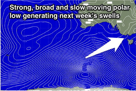
Our strong pulses of S/SW groundswell for Sunday and Monday are still on track, with the vigorous and slow moving polar low linked to these swells already developing to our south-southwest.
A fetch of gale to severe-gale SW winds are being generated in our southern swell window, projecting east-northeast towards Vicco/SA, while a secondary weaker frontal system will project north-east towards us during tomorrow and Sunday morning.
What should result is a strong pulse of long-period S/SW groundswell through Sunday, peaking through the early afternoon in the South West, later in Perth and arriving later up at Gero.
A secondary slightly smaller S/SW pulse should follow closely behind, peaking early Monday (during the afternoon around Gero) before easing into the afternoon.
Size wise Margs should reach 6ft+ at exposed breaks Sunday afternoon, 2ft in Perth and 3-4ft by dark up at Gero.
Monday morning then looks to be easing from the 6ft range in the South West 2ft all day in Perth and 3ft to near 5ft up at Gero.
Winds as touched on last update won't be great but will be workable Sunday and from the S/SE across most locations, favouring protected locations, while Monday looks excellent with a fresh to strong E/SE offshore developing across all locations. Late morning will probably be best as winds ease before sea breezes kick in.
The swell should continue to ease through Tuesday under great E/NE winds, which will even tend NE up at Gero.
Longer term there's nothing too major on the cards with a couple of weak SW swells for the end of the week with workable winds. We may see a better increase in size later in the weekend/the following week but we'll review this Monday. Have a great weekend!