Not much to work with this period

Victorian Surf Forecast by Craig Brokensha (issued Wednesday 3rd March)
Best Days: Desperate surfers Surf Coast tomorrow morning for small waves, keen surfers late morning Saturday, exposed beaches Sunday morning
Features of the Forecast (tl;dr)
- Low point in swell tomorrow with morning W/NW winds, shifting W/SW late morning and then strengthening from the SW
- New mid-period SW swell building Fri but with strong S/SW winds, peaking Sat out of the S/SW with moderate morning S/SE winds, easing Sun with a morning N/NE breeze
- Good new SW groundswell Tuesday but with strong S/SW winds
Recap
Generally poor conditions yesterday with plenty of swell but a strong onshore wind, improving a touch into the afternoon as winds backed off a little.
Today we've got less swell and persistent onshore winds, creating choppy, poor surf again.
This week and weekend (Mar 4 - 7)
We'll see the surf continuing to ease in size and power tomorrow as winds swing around to the W/NW for a period through the morning, cleaning up the Surf Coast. Size wise sets only look to reach 2ft with bumpy 3-4ft sets to the east. Conditions will start to deteriorate again from late morning as winds shift W/SW and then stronger SW into the evening.
This change in winds will be linked to a strengthening polar front firing up south-west of Tassie, in our south-western swell window tomorrow, clipping the state into the afternoon and evening.
 The size off this system looks a touch better with it due to be a bit stronger, but with an increase in intensity of the front, we'll see onshore winds now lingering into Saturday instead of tending variable as it keeps a high to the west.
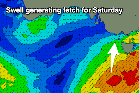
The swell generating properties of the front will see a fetch of strengthening strong to gale-force S/SW winds firing up in our southern swell window, producing a mid-period S/SW swell for Saturday. Friday will see some weaker energy on the build though with the Surf Coast due to build to 3ft to possibly 4ft but with strong S/SW winds. The Mornington Peninsula should build to 4-5ft+.
The strongest pulse of swell Saturday will have a fair bit of south in it with 3-4ft surf continuing on the Surf Coast, 4-5ft to the east, easing into Sunday from 2ft+ and 3ft+ respectively.
Winds on Saturday, as touched on above will linger from the S/SE, light to moderate (check back Friday for one final look as the models diverge a touch), while Sunday still looks fun for the exposed beaches with a N/NE offshore ahead of sea breezes.
Next week onwards (Mar 8 onwards)
 We'll see a small surface trough bring onshore SW winds back to the fold on Monday with a low point in swell, but our new groundswell mentioned last update is on track for Tuesday. Unfortunately so are the strong S/SW winds in the wake of the trough.
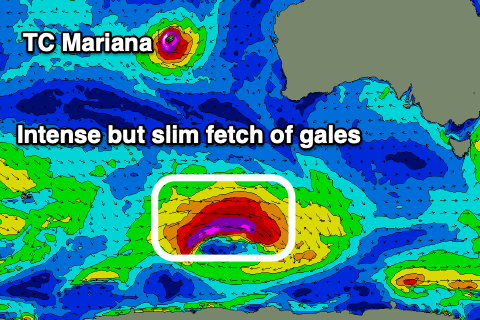
Looking at the swell though and a cold front pushing south-east from a position north of the Heard Island region, will form into a low south-west of WA. This will then see a slim fetch of severe-gale to near storm-force W/NW winds generated in our swell window, swinging more W while weakening south-west of Tassie on Sunday.
A moderate sized, long-period SW groundswell should be seen, arriving on dark Monday and peaking Tuesday to 4ft on the Surf Coast swell magnets, 6ft+ to the east though with those strong S/SW winds.
S'ly winds look to persist Wednesday as the swell eases, possibly cleaner on the beaches Thursday though we'll review this on Friday.