Good swell mid-week and then fun on the beaches for the weekend

Victoria Forecast by Craig Brokensha (issued Monday 26th August)
Best Days: Surf Coast Tuesday morning, Wednesday morning, selected spots Friday but more so Saturday on the exposed beaches
Recap
A mix of swells all weekend, hovering around the 3ft range on the sets across the Surf Coast magnets with generally favourable winds, bigger and bumpier to the east.
Today the swell is similar in size, best on the Surf Coast again with the W/NW-NW breeze.
Today’s Forecaster Notes are brought to you by Rip Curl
This week and weekend (Aug 27 – Sep 1)
The mix of swells seen over the past few days will start to lose size and consistency through tomorrow, dropping from 2ft to possibly 3ft on the Surf Coast swell magnets and the 4ft range to the east with a W/NW tending variable breeze.
 Our new SW groundswell for Wednesday is looking good and we've got a morning of gusty NW winds ahead of a midday SW change.
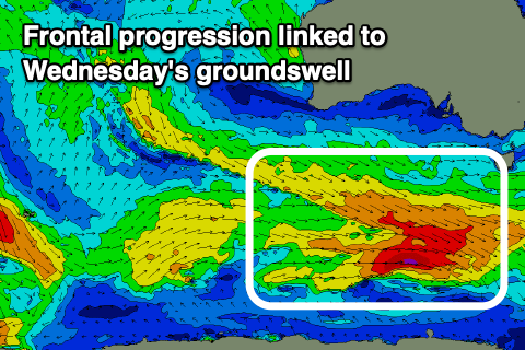
Over the last couple of days an east-southeast tracking frontal progression has been generating W/NW fetches in our south-western swell window, with an intensification yesterday afternoon seeing winds reach gale-force.
A moderate sized SW groundswell is expected of this activity, arriving overnight Tuesday and peaking Wednesday to 4ft on the Surf Coast and 6ft on the sets across the Mornington Peninsula. The change will bring an additional increase in SW windswell through the afternoon but the models are combing this with the existing groundswell and over-forecasting the size.
Some new mid-period SW swell will be seen into Thursday though as the SW groundswell eases, ahead of a new S/SW groundswell on Friday produced by a trailing polar fetch of W/SW gales following Wednesday's front.
Size wise, Thursday looks to come in 3-4ft on the Surf Coast and 5-6ft to the east but with onshore S/SW tending S winds in the wake of Wednesday's change.
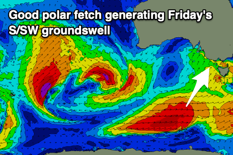 As talked about last Friday, a high is due to move in quickly from the west on Friday, swinging winds around to the NE if we look as GFS, but ECMWF has the front-come-trough slower moving as a low forms off the southern NSW coast. This will result in less favourable E'ly winds, with the new S/SW groundswell to 3-5ft on the Surf Coast and 5-6ft+ to the east. Check back Wednesday for a clearer idea on the wind outlook for Friday.
Which ever way the winds go on Friday, Saturday looks great for the beaches with the models both having N'ly winds and easing levels of swell from 2-3ft and 4ft+ respectively. Sunday looks average with small leftovers and stronger N'ly winds ahead of a change.
Longer term it looks like we'll see plenty of activity through our western swell window as a strong negative Southern Annular Mode (SAM/AAO) is forecast for the start of September. This will see the westerly storm track shifted more northerly, with all the activity currently forecast to fire up south-west and south of WA at this stage. For more on the SAM watch the video below.
Comments
Thank you for the video. Great to get learning content on the forecaster notes.
We've covered the SAM a bit before (in other contexts):
Feb 2017: "Explaining the East Coast's cruel summer"
https://www.swellnet.com/news/swellnet-analysis/2017/02/09/explaining-ea...
June 2017: "Western and South Australia's stellar run of swell"
https://www.swellnet.com/news/swellnet-analysis/2017/06/29/western-and-s...
Aug 2018: "Explained: Western Australia's return to winter and East Coast flat spell"
https://www.swellnet.com/news/swellnet-analysis/2018/08/14/explained-wes...
whats your guys predictions on the waves for the rest of the Tahiti comp in a sentence
Best off discussing in the right article.
https://www.swellnet.com/news/swellnet-analysis/2019/08/22/tahiti-pro-te...