Indonesia/Maldives forecast Jul 8

Indian Ocean Basin analysis by Craig Brokensha (issued Tuesday 8th July)
This week through next (July 9 - 11)
Following a couple of slower, smaller swells we look towards the large S/SW groundswell due into tomorrow and Thursday.
The strong frontal progression linked to this swell has come and gone, with an initial fetch of severe-gale SW winds setting in motion an active sea state for a secondary system to quickly push up and on top of, projecting an additional closer-range but slightly weaker fetch towards us.
A large, consistent S/SW groundswell is due from this progression with a couple of mixed swell trains but we should see the exposed breaks building rapidly tomorrow afternoon, large late and holding into Thursday morning.
A downwards trend is then due into the end of the week and start of the weekend.
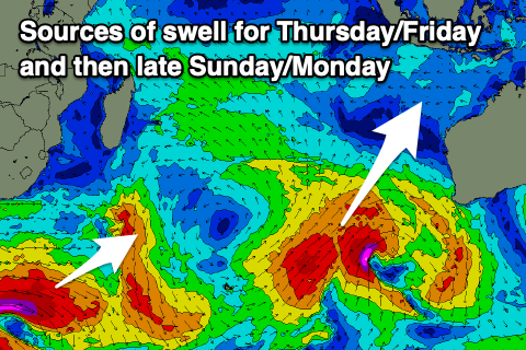
An inconsistent and acute S/SW groundswell is due later Saturday and Sunday morning, generated by a final front following the progression up towards Western Australia today, with it halting the easing trend through Saturday.
Otherwise we’ve got an inconsistent, long-range SW groundswell for Sunday afternoon and Monday morning, generated by a strong but distant low that formed south of South Africa over the weekend.
A fetch of severe-gale to storm-force W’ly winds were generated, but the storm then broke down while pushing further east. It looks moderate + in size.
Otherwise, besides some moderate sized, mid-period swell mid-week, we look towards a mix of long-range groundswells due into the end of the week.
This will be thanks to a rolling scrum of strong polar frontal activity moving in from the south-east of South Africa, forming later this week. An initial strong polar low looks to generate a great fetch of storm-force W/NW winds, projecting towards the Heard Island region while expanding and slowly weakening.
This by itself is likely to generate an inconsistent, moderate to large S/SW groundswell, but additional activity moving over the same area and an active sea state should boost the swell to the large range. We then may see further activity south-west of Western Australia, maintaining the size of the swell, but at this stage we’ll just deal with what’s currently forecast.

Large, slightly inconsistent S/SW groundswell energy is due to build Thursday and peak Friday, easing slowly from the following weekend.
The current, strong E/SE trades are expected to ease a little over the coming days while tending SE, increasing slowly over the weekend but more so next week from the E/SE-SE.
Early each morning, light local land breezes are expected.
In the Mentawais the coming swell activity will come in more south and with a touch less size, though the magnets across southern regions will still be large over the coming days, with the swell for later next week due to come in slower and smaller.
Local winds look variable this period with southern regions possibly seeing SE breezes Thursday.
----------------------------------------------
Maldives:
Following the weekend’s large S’ly swell energy, we then look to the super-charged S/SE trade-swell due through this week, with an impressive fetch of strong E/SE trades currently set up south and south-east of the region.

Various intensifications over the coming days will generate moderate to large pulses of S/SE tending SE swell this week, strongest Thursday/Friday before easing slowly thereafter as the trade fetch starts to break down later week.
The downwards trend will only be short-lived, with a re-intensification of trades expected through the weekend and into early next week, possibly stronger than the current setup. This would generate a fresh pulse of large S/SE trade-swell through the middle of next week, but check back here on Thursday for more on this.
S’ly groundswell wise, the strong system projecting towards Western Australia is due to generate a swell that will come under the localised SE trade-swell later week.
The strong but short-lived low that formed south of South Africa on the weekend should produce a small to moderate sized pulse of swell for Saturday, easing Sunday, slower thereafter.
Local winds look favourable with W-W/NW winds due across northern and central locations for the coming week, variable across the south from tomorrow.
Winds may strengthen out of the W/NW across northern locations from later Friday but more so the weekend, a little weaker next week but persisting.
Eastern Indonesia:
Large, consistent S/SW groundswell building tomorrow afternoon, reaching 10ft on dark across exposed breaks, easing slowly Thursday from a similar size.
Small to moderate sized, reinforcing S/SW groundswell for later Saturday/Sunday morning.
Moderate + sized, inconsistent SW groundswell building Sunday afternoon to 5-6ft, easing Monday from a similar size across exposed breaks.
Large mix of S/SW groundswells likely later next week.
The current, strong E/SE trades are expected to ease a little over the coming days while tending SE, increasing slowly over the weekend but more so next week from the E/SE-SE. Lighter, local offshore winds each morning.
Uluwatu 16-day Forecast Graph/WAMs
Western Indonesia/Mentawais/South Sumatra:
Large S’ly groundswells building tomorrow afternoon, reaching 8ft to possibly 10ft later, easing from a similar size Thursday morning.
Moderate + sized, inconsistent SW groundswell building Sunday afternoon to 6ft, easing Monday from a similar size across exposed breaks.
Large, inconsistent S/SW groundswell for later next week/weekend.
Variable winds this period, possibly tending SE Thursday across southern locations.
Mentawai 16-day Forecast Graph/WAMs
Maldives:
Super-charged S/SE-SE trade-swell building tomorrow, peaking Thursday/Friday to 6ft+ across the southern atolls, smaller Male.
Swell easing slowly from Friday afternoon from the SE.
Super-charged S/SE trade-swell event likely again next week.
Smaller pulses of background groundswell for Friday through Sunday.
Light to moderate W-W/NW winds across northern and central locations for the coming week, variable across the south from tomorrow.
Winds may strengthen out of the W/NW across northern locations from later Friday but more so the weekend, a little weaker next week but persisting.
Comments
Latest notes are live.
Here’s Craigs update, it slipped down the page , thanks Lord Craigos
Righto, Kandooma this time next week. If I’m comprehending correctly; should be ok?
I arrive the following Tuesday, 22nd for 10 nights Hendo
I’m Tuesday to Tuesday
Looks like you are in for some swell
Pumping here last night and today easy 6-8
Nice, Got reports from G Land that the swell kicked strongly into the afternoon/evening with Launching Pads coming in at 8ft or so on dark, but a little south.
A mate that lives on NL ducks over to G-Land when it looks good , he was stressing a bit as he went by boat and the boards went overland. First day boards hadn’t turned up and he had to buy a cheapie , he ended up getting a few .

Oh yeah!